Geolocate

Bahai topographic map

Interactive map

Click on the map to display elevation.

About this map

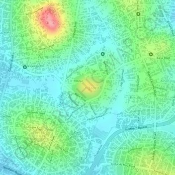
Name: Bahai topographic map, elevation, terrain.

Location: Bahai, Kawempe, Kampala, Central Region, Uganda (0.36256 32.58578 0.36664 32.59073)

Average elevation: 1,200 m

Minimum elevation: 1,167 m

Maximum elevation: 1,281 m

Other topographic maps

Click on a map to view its topography, its elevation and its terrain.

Central

Uganda > Central Region > Kampala

Average elevation: 1,193 m

Shimoni

Uganda > Central Region > Kampala

Average elevation: 1,182 m

Wansanso (zone)

Uganda > Central Region > Kampala

Average elevation: 1,182 m

Kikandwa

Uganda > Central Region > Kampala

Average elevation: 1,191 m

Isreal-matovu

Uganda > Central Region > Kampala

Average elevation: 1,187 m

Isreal-matovu

Uganda > Central Region > Kampala

Average elevation: 1,187 m

Central

Uganda > Central Region > Kampala

Average elevation: 1,193 m

Rubaga

Uganda > Central Region > Kampala

Average elevation: 1,187 m

Kawempe

Uganda > Central Region > Kampala

Average elevation: 1,196 m