
Spa topographic map
Click on the map to display elevation.
Spa
Spa has an oceanic climate that is made more continental by its higher elevation and inland position compared to other Belgian climates at lower level or closer to the sea. Spa has a relatively high precipitation year round, with tricky weather something that the Spa-Francorchamps race track is known for. The elevation also results in cooler summers and frequent winter frost along with snowfall. Spa is quite gloomy year round although averaging both a drier and sunnier climate than nearby locations Stavelot and Malmedy that are also surrounding the race track.
About this map
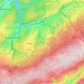
Name: Spa topographic map, elevation, terrain.
Location: Spa, Verviers, Liège, Wallonia, 4900, Belgium (50.43356 5.81536 50.51212 5.93175)
Average elevation: 402 m
Minimum elevation: 192 m
Maximum elevation: 580 m
Other topographic maps
Click on a map to view its topography, its elevation and its terrain.
Ardennes
Belgium > Liège > Verviers > Robertville
The region was uplifted by a mantle plume during the last few hundred thousand years, as measured from the present elevation of old river terraces.
Average elevation: 659 m
Stavelot
Belgium > Liège > Verviers > Stavelot
Stavelot has an oceanic climate influenced by its high elevation and inland position towards a more continental type by Belgian standards. Being located at a lower elevation than neighbouring village Malmedy at the other end of the original layout of the Spa-Francorchamps race track, Stavelot is slightly…
Average elevation: 401 m
Ardennes
Belgium > Liège > Verviers > Robertville
The region the Ardennes are part of has been uplifted further in the last few hundred thousand years by a mantle plume, as measured from the present elevation of old river terraces, with the largest amount of uplift concentrated in the east, where the Ardennes connect with the Eifel, where the same mantle…
Average elevation: 659 m
Signal de Botrange
Belgium > Liège > Verviers > Robertville
In 1923, the 6-metre (20-foot) Baltia tower was built on the summit to allow visitors to reach an altitude of 700 m (2,300 ft). A stone tower built in 1933/34 by François Fagnoul from Ovifat on the Botrange crowned a steel weather vane with the relieved name SICCO CAMPO until World War II. Meanwhile, the…
Average elevation: 659 m