
Make a donation
Gear up for your next adventure:
As an Amazon Associate, this site earns from qualifying purchases at no extra cost to you.
Castaic topographic map
Click on the map to display elevation.
Make a donation
Gear up for your next adventure:
As an Amazon Associate, this site earns from qualifying purchases at no extra cost to you.
About this map
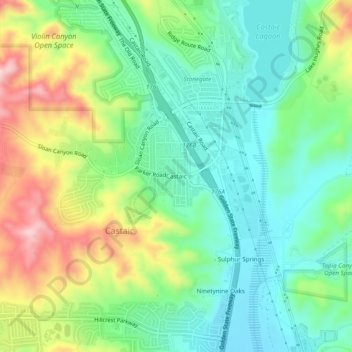
Name: Castaic topographic map, elevation, terrain.
Location: Castaic, California, 91384, United States (34.46888 -118.64287 34.50888 -118.60287)
Average elevation: 418 m
Minimum elevation: 326 m
Maximum elevation: 595 m
Make a donation
Gear up for your next adventure:
As an Amazon Associate, this site earns from qualifying purchases at no extra cost to you.
Other topographic maps
Click on a map to view its topography, its elevation and its terrain.
San Francisco
San Francisco is characterized by its striking and varied topography, making it one of the most distinctive cities in the United States. The landscape features a mix of rolling hills and steep inclines, with the highest elevation reaching approximately 922 feet at Twin Peaks. The average elevation across the…
Average elevation: 65 m
San Diego
United States > California > San Diego County
San Diego is characterized by a diverse topography that features coastal plains, rolling hills, and rugged mountain ranges. The city is situated along the Pacific Ocean, where it boasts an extensive shoreline with sandy beaches and tidal zones. As you move inland, the landscape transitions from the flat…
Average elevation: 125 m
Los Angeles
United States > California > Los Angeles County
Los Angeles is characterized by a diverse and dynamic topography. The city is predominantly situated in a basin bordered by mountain ranges, including the Santa Monica Mountains to the north and the San Gabriel Mountains to the east, with elevations reaching up to about 10,000 feet (3,048 meters) in certain…
Average elevation: 241 m
Oakland
United States > California > Alameda County
Oakland features a diverse topography shaped by its location along the eastern shore of San Francisco Bay and the presence of the nearby coastal hills. The city sits on a flat coastal plain that gradually ascends toward the Oakland Hills to the east, where elevations can exceed 1,700 feet. The highest point…
Average elevation: 51 m
Make a donation
Gear up for your next adventure:
As an Amazon Associate, this site earns from qualifying purchases at no extra cost to you.
Lake Tahoe
United States > California > Placer County
Lake Tahoe is renowned for its dramatic topography, characterized by rugged mountain ranges and deep, crystal-clear waters. Nestled in the Sierra Nevada, the lake itself lies at an elevation of approximately 6,225 feet (1,897 meters) and spans about 22 miles (35 kilometers) in length and 12 miles (19…
Average elevation: 2,077 m
Bakersfield
United States > California > Kern County
Most of Bakersfield's major streets are six-lane divided roads with bike lanes, with almost every street in the city having proper lane signage for bicycle traffic. Bikes are a popular method of transportation in Bakersfield, due to the city's relatively flat topography and grid-like street system. Newer…
Average elevation: 157 m
Los Angeles
United States > California > Los Angeles County
Los Angeles is characterized by a diverse and dynamic topography. The city is predominantly situated in a basin bordered by mountain ranges, including the Santa Monica Mountains to the north and the San Gabriel Mountains to the east, with elevations reaching up to about 10,000 feet (3,048 meters) in certain…
Average elevation: 241 m
San Jose
United States > California > Santa Clara County
San Jose, located in Santa Clara County, California, features a diverse topography characterized by a mix of low-lying plains and rolling hills. The city sits at an average elevation of approximately 82 feet (25 meters) above sea level, with the surrounding terrain including the foothills of the Santa Cruz…
Average elevation: 265 m
Make a donation
Gear up for your next adventure:
As an Amazon Associate, this site earns from qualifying purchases at no extra cost to you.
Berkeley
United States > California > Alameda County
Berkeley, located on the eastern shore of San Francisco Bay, features a diverse topography characterized by rolling hills and steep slopes. The city sits at an elevation that ranges from sea level along the bay to about 1,300 feet (396 meters) in the Berkeley Hills. This hilly landscape provides stunning views…
Average elevation: 109 m
Santa Clara County
Santa Clara County features a diverse and varied topography characterized by both low-lying valleys and rugged mountainous regions. The county encompasses a significant portion of Silicon Valley, where flat, urbanized areas are interspersed with rolling hills and foothills that rise sharply in the Santa Cruz…
Average elevation: 323 m
Los Angeles County
Los Angeles County's topography is characterized by a diverse landscape that includes coastal plains, mountain ranges, and expansive valleys. The county is situated within the Los Angeles Basin, a large sedimentary basin bounded by the Santa Monica Mountains to the north and the San Gabriel Mountains to the…
Average elevation: 378 m
Make a donation
Gear up for your next adventure:
As an Amazon Associate, this site earns from qualifying purchases at no extra cost to you.
Yosemite National Park
The geology of the Yosemite area is characterized by granite rocks and remnants of older rock. About 10 million years ago, the Sierra Nevada was uplifted and tilted to form its unique slopes, which increased the steepness of stream and river beds, resulting in the formation of deep, narrow canyons. About one…
Average elevation: 2,337 m
Redding
United States > California > Shasta County
The elevation in Redding is 495 feet (151 meters) on average, whereas anywhere to the north, east, or west of downtown ranges between 550 feet (170 m) and 800 feet (240 m) feet. Southern portions range between 400 feet (120 m) and 500 feet (150 m).
Average elevation: 240 m
Yosemite National Park
The geology of the Yosemite area is characterized by granite rocks and remnants of older rock. About 10 million years ago, the Sierra Nevada was uplifted and tilted to form its unique slopes, which increased the steepness of stream and river beds, resulting in the formation of deep, narrow canyons. About one…
Average elevation: 2,337 m
Pasadena
United States > California > Los Angeles County
An obscure portion of the Angeles Crest Highway (SR 2) in the San Gabriel Mountains cuts through Pasadena near the Angeles Crest Ranger Station. This 2-mile (3.2 km) stretch of highway in the Angeles National Forest is north of La Cañada Flintridge and west of Mount Wilson and is approximately 3,000 feet (910…
Average elevation: 548 m
Make a donation
Gear up for your next adventure:
As an Amazon Associate, this site earns from qualifying purchases at no extra cost to you.
Amador County
Amador County ranges in elevation from approximately 250 feet (76 m) in the western portion of the county to over 9,000 feet (2,700 m) in the eastern portion of the county, the tallest point being Thunder Mountain. The county is bordered on the north by the Cosumnes River and El Dorado County and on the south…
Average elevation: 896 m
Palm Springs
United States > California > Riverside County
One possible origin of palm in the place name comes from early Spanish explorers who referred to the area as La Palma de la Mano de Dios or "The Palm of God's hand". The earliest use of the name "Palm Springs" is from United States Topographical Engineers who used the term in 1853 maps. According to William…
Average elevation: 859 m
Redding
United States > California > Shasta County
The elevation in Redding is 495 feet (151 meters) on average, whereas anywhere to the north, east, or west of downtown ranges between 550 feet (170 m) and 800 feet (240 m) feet. Southern portions range between 400 feet (120 m) and 500 feet (150 m).
Average elevation: 241 m
Make a donation
Gear up for your next adventure:
As an Amazon Associate, this site earns from qualifying purchases at no extra cost to you.
Death Valley
Death Valley's Badwater Basin is the point of lowest elevation in North America, at 282 feet (86 m) below sea level. It is 84.6 miles (136.2 km) east-southeast of Mount Whitney, the highest point in the contiguous United States, with an elevation of 14,505 feet (4,421 m). On the afternoon of July 10, 1913, the…
Average elevation: 1,085 m
Napa County
Napa is warmer in the summer than Sonoma County, to the west, or Santa Barbara County, a wine-producing county in southern California. Thus, the Napa wineries favor varietals such as Cabernet Sauvignon, while Pinot noir and Chardonnay are more the specialty of Sonoma and Santa Barbara wineries. At the north…
Average elevation: 232 m
Make a donation
Gear up for your next adventure:
As an Amazon Associate, this site earns from qualifying purchases at no extra cost to you.
Santa Cruz Mountains
United States > California > Santa Clara County
The Santa Cruz Mountains are a region of great biological diversity, encompassing cool, moist coastal ecosystems as well as warm, dry chaparral. Much of the area in the Santa Cruz mountains is considered temperate rainforest. In valleys and moist ocean-facing slopes some of the southernmost coast redwoods…
Average elevation: 230 m
Sonoma County
Sonoma County, as is often the case with coastal counties in California, has a great degree of climatic variation and numerous, often very different, microclimates. Key determining factors for local climate are proximity to the ocean, elevation, and the presence and elevation of hills or mountains to the east…
Average elevation: 210 m
Make a donation
Gear up for your next adventure:
As an Amazon Associate, this site earns from qualifying purchases at no extra cost to you.
Walnut Creek
United States > California > Contra Costa County
Walnut Creek's warm summer Mediterranean climate (Köppen climate classification Csb) is typical of California's interior valleys. In summer, high pressure results in almost unbroken sunshine and virtually no precipitation. Days start out cool but quickly warm up, with high temperatures normally in the 80s…
Average elevation: 119 m
Long Beach
United States > California > Los Angeles County
Willow Springs Park was founded as a part of the Willow Springs Wetlands Restoration Project which opened in October 2017. The project restored 11 acres of a 48-acre degraded oil well site into wetlands. These highlight the pivotal role the ecosystem played in the City of Long Beach’s establishment in the…
Average elevation: 12 m
Make a donation
Gear up for your next adventure:
As an Amazon Associate, this site earns from qualifying purchases at no extra cost to you.
Santa Catalina Island
United States > California > Los Angeles County > Avalon
Catalina is primarily composed of two distinct rock units: Catalina Schist from the Early Cretaceous (95 to 109 million years ago), and Miocene volcanic and intrusive igneous rocks. The island is rich in quartz, to the extent that some beaches on the seaward side have silvery-grey sand. These formations…
Average elevation: 60 m
El Dorado Hills
United States > California > El Dorado County > Cameron Park
El Dorado Hills (EDH), as defined by the 2010 census-designated place (CDP), is at the western border of El Dorado County, between the City of Folsom and the unincorporated community of Cameron Park. The northern limits of the CDP are Folsom Lake and the South Fork of the American River, where river rafters…
Average elevation: 254 m
Make a donation
Gear up for your next adventure:
As an Amazon Associate, this site earns from qualifying purchases at no extra cost to you.
Sonoma County
Sonoma County, as is often the case with coastal counties in California, has a great degree of climatic variation and numerous, often very different, microclimates. Key determining factors for local climate are proximity to the ocean, elevation, and the presence and elevation of hills or mountains to the east…
Average elevation: 210 m
Eureka
United States > California > Humboldt County
Eureka, located along Humboldt Bay in Northern California, has a diverse and varied topography. The city itself is situated at relatively low elevations, with the bay’s narrow point serving as a key feature in the landscape. Its average elevation is around 50 feet (15 meters), and the terrain gently rises…
Average elevation: 15 m
Make a donation
Gear up for your next adventure:
As an Amazon Associate, this site earns from qualifying purchases at no extra cost to you.
South Lake Tahoe
United States > California > El Dorado County
According to the United States Census Bureau, the city has a total area of 16.6 square miles (43 km2), of which 10.2 square miles (26 km2) is land and 6.4 square miles (17 km2), or 38.80%, is water. Its elevation is about 6,237 feet (1,901 m) above sea level.
Average elevation: 1,979 m
Make a donation
Gear up for your next adventure:
As an Amazon Associate, this site earns from qualifying purchases at no extra cost to you.
San Diego County
San Diego County's topography is marked by its dramatic variety, ranging from coastal plains to mountainous regions. The county stretches along California's southern border, with a coastline that includes sandy beaches, cliffs, and bays, such as the iconic San Diego Bay. Inland, the terrain rises into the…
Average elevation: 544 m
Death Valley
Death Valley's Badwater Basin is the point of lowest elevation in North America, at 282 feet (86 m) below sea level. It is 84.6 miles (136.2 km) east-southeast of Mount Whitney — the highest point in the contiguous United States, with an elevation of 14,505 feet (4,421 m). On the afternoon of July 10, 1913,…
Average elevation: 1,085 m
Make a donation
Gear up for your next adventure:
As an Amazon Associate, this site earns from qualifying purchases at no extra cost to you.
Newport Beach
United States > California > Orange County
Newport Beach, located in Orange County, California, features a dynamic and varied topography shaped by its coastal position and surrounding hills. The city spans from sea level along its beaches to elevations of over 1,100 feet (335 meters) in the nearby San Joaquin Hills. These hills, particularly noticeable…
Average elevation: 14 m
Lone Pine
United States > California > Inyo County
Lone Pine is a census-designated place (CDP) in Inyo County, California, United States. Lone Pine is located 16 mi (26 km) south-southeast of Independence, at an elevation of 3,727 ft (1,136 m). The population was 2,035 at the 2010 census, up from 1,655 at the 2000 census. The town is located in the Owens…
Average elevation: 1,298 m
Make a donation
Gear up for your next adventure:
As an Amazon Associate, this site earns from qualifying purchases at no extra cost to you.
San Leandro
United States > California > Alameda County
The San Leandro Hills run above the city to the northeast. In the lower elevations of the city, an upper regionally contained aquifer is located 50 to 100 feet (15 to 30 m) below the surface. At least one deeper aquifer exists approximately 250 feet (75 m) below the surface. Some salt water intrusion has taken…
Average elevation: 21 m
Make a donation
Gear up for your next adventure:
As an Amazon Associate, this site earns from qualifying purchases at no extra cost to you.
Indio
United States > California > Riverside County
Indio is home of Riverside County's eastern administration offices. Palm Springs had more people from 1955 to 1992, when the US census announced that Indio surpassed Palm Springs and that title was returned to them. The official elevation of Indio is below sea level; the city hall is 14 feet (4 m) below sea…
Average elevation: 74 m
Santa Catalina Island
United States > California > Los Angeles County > Avalon
Santa Catalina Island (Spanish: Isla Santa Catalina; Tongva: Pimu) often shortened to Catalina Island or Catalina, is a rocky island, part of the Channel Islands, off the coast of Southern California in the Gulf of Santa Catalina. The island covers an area of about 75 square miles (194 square kilometers). It…
Average elevation: 60 m
Make a donation
Gear up for your next adventure:
As an Amazon Associate, this site earns from qualifying purchases at no extra cost to you.
Sonora
United States > California > Tuolumne County
Sonora is located at 37°59′04″N 120°22′54″W / 37.984361°N 120.381767°W / 37.984361; -120.381767, around the intersection of California State Highways 49 and 108 The altitude is 1,825 feet (556 m). According to the United States Census Bureau, the city has a total area of 3.1 square miles…
Average elevation: 615 m
Make a donation
Gear up for your next adventure:
As an Amazon Associate, this site earns from qualifying purchases at no extra cost to you.
Oceanside
United States > California > San Diego County
Oceanside features a diverse topography characterized by its coastal setting and gentle inland elevations. The city is predominantly flat, with its elevation averaging around 66 feet (20 meters) above sea level, allowing for expansive views of the Pacific Ocean along its roughly 3.5 miles of coastline. Inland,…
Average elevation: 32 m
Roseville
United States > California > Placer County
Roseville has a hot-summer Mediterranean climate that is characterized by cool, wet, usually snowless winters and hot, dry summers (Köppen Csa). The wet season is generally October through April. Because Roseville is east of Sacramento and at a higher elevation, it receives slightly more rainfall. Average…
Average elevation: 67 m
Victorville
United States > California > San Bernardino County
Victorville is bordered by Apple Valley on the east, Hesperia on the south, and Adelanto on the west. The Mojave River flows sporadically through Victorville. The elevation at City Hall is approximately 2,950 feet (900 m) above sea level.
Average elevation: 920 m
Make a donation
Gear up for your next adventure:
As an Amazon Associate, this site earns from qualifying purchases at no extra cost to you.
San Ramon
United States > California > Contra Costa County
The topography of San Ramon is varied, featuring a mix of the rolling hills of the Diablo Range and the flatter basin of the San Ramon Valley. The city is predominantly urban and residential with many new housing developments; however, much of the land around the city's perimeter regions remains undeveloped,…
Average elevation: 210 m
Santa Clarita
United States > California > Los Angeles County
The official elevation of the city is 1,207 feet (368 m), the elevation of the historic Newhall Airport which was northwest of Via Princessa and Railroad Avenue from the 1930s through the 1950s. Elevation varies substantially throughout the city. The lowest point in Santa Clarita is near the junction of CA-126…
Average elevation: 514 m
Make a donation
Gear up for your next adventure:
As an Amazon Associate, this site earns from qualifying purchases at no extra cost to you.
Sequoia National Park
United States > California > Tulare County
Many park visitors enter Sequoia National Park through its southern entrance near the town of Three Rivers at Ash Mountain at 1,700 ft (520 m) elevation. The lower elevations around Ash Mountain contain the only National Park Service-protected California Foothills ecosystem, consisting of blue oak woodlands,…
Average elevation: 2,515 m
Make a donation
Gear up for your next adventure:
As an Amazon Associate, this site earns from qualifying purchases at no extra cost to you.
Del Norte County
The mountainous terrain associated with the Coastal Range and the Klamath Mountains dominates Del Norte County's geography. Elevation ranges from sea level to over 6,400 feet. Although much of the county is made up of steep terrain, there are small patches of flat terrain along the coast and in isolated…
Average elevation: 551 m
Roseville
United States > California > Placer County
Roseville has a hot-summer Mediterranean climate that is characterized by cool, wet, usually snowless winters and hot, dry summers (Köppen Csa). The wet season is generally October through April. Because Roseville is east of Sacramento and at a higher elevation, it receives slightly more rainfall. Average…
Average elevation: 67 m
Make a donation
Gear up for your next adventure:
As an Amazon Associate, this site earns from qualifying purchases at no extra cost to you.
Make a donation
Gear up for your next adventure:
As an Amazon Associate, this site earns from qualifying purchases at no extra cost to you.
Encinitas
United States > California > San Diego County
Encinitas lies on rugged coastal terrace. The city is bisected by a low-lying coastal ridge that separates New and Old Encinitas. In the north of the city, the coast rises in elevation and the land is raised up in the form of many coastal bluffs. These cliffs are subject to collapsing on the narrow beach. The…
Average elevation: 32 m
Make a donation
Gear up for your next adventure:
As an Amazon Associate, this site earns from qualifying purchases at no extra cost to you.
El Dorado County
El Dorado County (/ˌɛl dəˈrɑːdoʊ/ (listen)), officially the County of El Dorado, is a county located in the U.S. state of California. As of the 2020 census, the population was 191,185. The county seat is Placerville. The County is part of the Sacramento-Roseville-Arden-Arcade, CA Metropolitan…
Average elevation: 1,286 m
Make a donation
Gear up for your next adventure:
As an Amazon Associate, this site earns from qualifying purchases at no extra cost to you.
Contra Costa County
In prehistoric times, particularly the Miocene epoch, portions of the landforms now in the area (then marshy and grassy savanna) were populated by a wide range of now extinct mammals, known in modern times by the fossil remains excavated in the southern part of the county. In the northern part of the county,…
Average elevation: 108 m
Ventura County
Ventura County can be separated into two major parts, East County and West County, which are divided by the Conejo Grade. East County consists of all cities east of the Conejo Grade. Geographically East County is the end of the Santa Monica Mountains, in which the Conejo Valley is located, and where there is a…
Average elevation: 331 m
La Mesa
United States > California > San Diego County
The climate in the San Diego area, like much of California, often varies significantly over short geographical distances, resulting in micro-climates. In San Diego's case, this is mainly due to the city's topography (the Bay, and the numerous hills, mountains, and canyons). Frequently, particularly during the…
Average elevation: 171 m
Palm Desert
United States > California > Riverside County
The elevation (at City Hall) is 224 feet (68 m) above sea level. Elevations vary from the lower northern half once covered in sand dunes to the upper slope southern cove (300–900 feet or 91–274 metres) all the way to the ridgeline at 1,000 feet (300 m). Palm Desert is in the Coachella Valley, the…
Average elevation: 178 m
Make a donation
Gear up for your next adventure:
As an Amazon Associate, this site earns from qualifying purchases at no extra cost to you.
Grass Valley
United States > California > Nevada County
Grass Valley is a city in Nevada County, California, United States. Situated at roughly 2,500 feet (760 m) in elevation in the western foothills of the Sierra Nevada mountain range, this northern Gold Country city is 57 miles (92 km) by car from Sacramento, 64 miles (103 km) from Sacramento International…
Average elevation: 773 m
Redwood National Park
United States > California > Del Norte County
Redwoods prefer sheltered slopes, and they thrive on moist flat ground along rivers below 1,000 feet (300 m) in elevation. Coastal fog provides about 40 percent of their annual water intake. Redwoods have existed along the coast of northern California for at least 20 million years and are related to tree…
Average elevation: 367 m
Nevada County Fairgrounds
United States > California > Nevada County > Grass Valley > Boston Ravine
Average elevation: 743 m
Make a donation
Gear up for your next adventure:
As an Amazon Associate, this site earns from qualifying purchases at no extra cost to you.