
Make a donation
Gear up for your next adventure:
As an Amazon Associate, this site earns from qualifying purchases at no extra cost to you.
Rincon topographic map
Click on the map to display elevation.
Make a donation
Gear up for your next adventure:
As an Amazon Associate, this site earns from qualifying purchases at no extra cost to you.
About this map
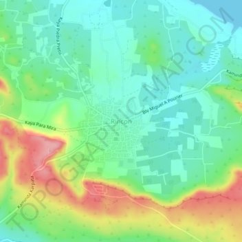
Name: Rincon topographic map, elevation, terrain.
Location: Rincon, Bonaire, Netherlands (12.21867 -68.34982 12.25867 -68.30982)
Average elevation: 40 m
Minimum elevation: 0 m
Maximum elevation: 119 m
Make a donation
Gear up for your next adventure:
As an Amazon Associate, this site earns from qualifying purchases at no extra cost to you.
Other topographic maps
Click on a map to view its topography, its elevation and its terrain.
Amsterdam
Amsterdam is located in the Western Netherlands, in the province of North Holland, the capital of which is not Amsterdam, but rather Haarlem. The river Amstel ends in the city centre and connects to a large number of canals that eventually terminate in the IJ. Amsterdam's elevation is about −2 m (−6.6 ft)…
Average elevation: 0 m
Make a donation
Gear up for your next adventure:
As an Amazon Associate, this site earns from qualifying purchases at no extra cost to you.
Eindhoven
The villages and city that make up modern Eindhoven were originally built on sandy elevations between the Dommel, Gender and Tongelreep rivers. Beginning in the 19th century, the basins of the rivers themselves have also been used as housing land, resulting in occasional flooding in the city centre. Partly to…
Average elevation: 20 m
Make a donation
Gear up for your next adventure:
As an Amazon Associate, this site earns from qualifying purchases at no extra cost to you.
Bonaire
While Bonaire has some hills and variations in altitude, Klein Bonaire's surface is quite level and just about two meters above sea level. Because Klein Bonaire is as yet undeveloped, the fringing reef system surrounding Klein Bonaire is pristine.
Average elevation: 1 m
Bonaire
Klein Bonaire, the small island in the sheltered lee of Bonaire, has the same geological history. While Bonaire has some hills and variations in altitude, Klein Bonaire's surface is quite level and just a few feet above high tide. Because the island is as yet undeveloped, the fringing reef system surrounding…
Average elevation: 1 m
Make a donation
Gear up for your next adventure:
As an Amazon Associate, this site earns from qualifying purchases at no extra cost to you.
Wageningen
Netherlands > Gelderland > Wageningen
Topographic map of the municipality of Wageningen, July 2013 (click to enlarge)
Average elevation: 14 m
Breda
Topographic map image of the city of Breda, March 2014. Click to enlarge.
Average elevation: 7 m
Make a donation
Gear up for your next adventure:
As an Amazon Associate, this site earns from qualifying purchases at no extra cost to you.
Make a donation
Gear up for your next adventure:
As an Amazon Associate, this site earns from qualifying purchases at no extra cost to you.
Make a donation
Gear up for your next adventure:
As an Amazon Associate, this site earns from qualifying purchases at no extra cost to you.
Heerlen
Heerlen's high elevation makes it one of the highest cities above sea level in the Netherlands.
Average elevation: 131 m
Eindhoven
The villages and city that make up modern Eindhoven were originally built on sandy elevations between the Dommel, Gender and Tongelreep rivers. Beginning in the 19th century, the basins of the rivers themselves have also been used as housing land, resulting in occasional flooding in the city centre. Partly to…
Average elevation: 20 m
Apeldoorn
In 1689 William III became King of England, Scotland and Ireland and this elevation of his position and power brought an enlargement of Het Loo in its wake. Between 1691 and 1694 the colonnades which linked the corps de logis to the wings on either side were replaced by four pavilions. These pavilions…
Average elevation: 26 m
Make a donation
Gear up for your next adventure:
As an Amazon Associate, this site earns from qualifying purchases at no extra cost to you.
Make a donation
Gear up for your next adventure:
As an Amazon Associate, this site earns from qualifying purchases at no extra cost to you.
Make a donation
Gear up for your next adventure:
As an Amazon Associate, this site earns from qualifying purchases at no extra cost to you.
Make a donation
Gear up for your next adventure:
As an Amazon Associate, this site earns from qualifying purchases at no extra cost to you.
Make a donation
Gear up for your next adventure:
As an Amazon Associate, this site earns from qualifying purchases at no extra cost to you.
Make a donation
Gear up for your next adventure:
As an Amazon Associate, this site earns from qualifying purchases at no extra cost to you.
Amersfoort
The construction of the tower and the church was started in 1444. The church was destroyed by an explosion in 1787, but the tower survived, and the layout of the church still can be discerned today through the use of different types of stone in the pavement of the open space that was created. It is now the…
Average elevation: 7 m
Make a donation
Gear up for your next adventure:
As an Amazon Associate, this site earns from qualifying purchases at no extra cost to you.
Dronten
Dutch Topographic map of Dronten (town), March 2014.
Average elevation: 0 m
Sliedrecht
Dutch topographic map of the municipality of Sliedrecht, June 2015
Average elevation: 0 m
Make a donation
Gear up for your next adventure:
As an Amazon Associate, this site earns from qualifying purchases at no extra cost to you.
Make a donation
Gear up for your next adventure:
As an Amazon Associate, this site earns from qualifying purchases at no extra cost to you.
Make a donation
Gear up for your next adventure:
As an Amazon Associate, this site earns from qualifying purchases at no extra cost to you.
Amsterdam
Amsterdam is located in the Western Netherlands, in the province of North Holland, the capital of which is not Amsterdam, but rather Haarlem. The river Amstel ends in the city centre and connects to a large number of canals that eventually terminate in the IJ. Amsterdam's elevation is about −2 m (−6.6 ft)…
Average elevation: 0 m
Make a donation
Gear up for your next adventure:
As an Amazon Associate, this site earns from qualifying purchases at no extra cost to you.
Make a donation
Gear up for your next adventure:
As an Amazon Associate, this site earns from qualifying purchases at no extra cost to you.
Make a donation
Gear up for your next adventure:
As an Amazon Associate, this site earns from qualifying purchases at no extra cost to you.
De Bilt
Dutch Topographic map of the municipality of De Bilt, June 2015
Average elevation: 4 m
Make a donation
Gear up for your next adventure:
As an Amazon Associate, this site earns from qualifying purchases at no extra cost to you.
Make a donation
Gear up for your next adventure:
As an Amazon Associate, this site earns from qualifying purchases at no extra cost to you.
Eindhoven
The villages and city that make up modern Eindhoven were originally built on sandy elevations between the Dommel, Gender and Tongelreep rivers. Beginning in the 19th century, the basins of the rivers themselves have also been used as housing land, resulting in occasional flooding in the city centre. Partly to…
Average elevation: 20 m
Make a donation
Gear up for your next adventure:
As an Amazon Associate, this site earns from qualifying purchases at no extra cost to you.
Make a donation
Gear up for your next adventure:
As an Amazon Associate, this site earns from qualifying purchases at no extra cost to you.
Landgraaf
Dutch topographic map of the municipality of Landgraaf, June 2015
Average elevation: 126 m
Make a donation
Gear up for your next adventure:
As an Amazon Associate, this site earns from qualifying purchases at no extra cost to you.