Geolocate

Costigliole Saluzzo topographic map

Interactive map

Click on the map to display elevation.

About this map

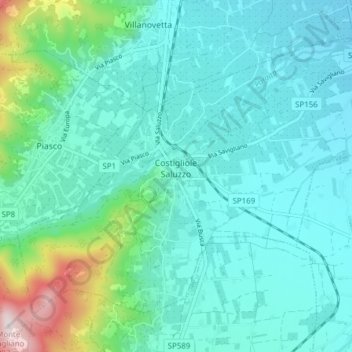
Name: Costigliole Saluzzo topographic map, elevation, terrain.

Location: Costigliole Saluzzo, Cuneo, Piedmont, Italy (44.54173 7.45070 44.58490 7.52747)

Average elevation: 501 m

Minimum elevation: 401 m

Maximum elevation: 972 m

Other topographic maps

Click on a map to view its topography, its elevation and its terrain.

Nitte

Italy > Piedmont > Cuneo > Verzuolo

Average elevation: 378 m

Borgo San Giuseppe

Italy > Piedmont > Cuneo > Cuneo

Average elevation: 520 m

Maschere

Italy > Piedmont > Cuneo > Saluzzo

Average elevation: 387 m

Beltramone

Italy > Piedmont > Cuneo > Barge

Average elevation: 614 m

Le Balme

Italy > Piedmont > Cuneo > Barge

Average elevation: 632 m

Cascina Dentis

Italy > Piedmont > Cuneo > Savigliano > Levaldigi

Average elevation: 376 m

Madonna della Neve

Italy > Piedmont > Cuneo > Clavesana

Average elevation: 329 m

Monte Pennino

Italy > Piedmont > Cuneo > Garessio

Average elevation: 1,068 m

Colle Fauniera

Italy > Piedmont > Cuneo > Demonte

The Colle Fauniera is a mountain pass in the Cottian Alps, Piedmont, northern Italy, located at 2,480+ m elevation.

Average elevation: 2,315 m

Duranda

Italy > Piedmont > Cuneo > Brossasco

Average elevation: 928 m

Pellerina

Italy > Piedmont > Cuneo > Chiusa di Pesio

Average elevation: 1,693 m

Prato Nevoso

Italy > Piedmont > Cuneo

Average elevation: 1,436 m

Monte Brancetta

Italy > Piedmont > Cuneo > Argentera

Average elevation: 2,467 m

Bric del Solio

Italy > Piedmont > Cuneo > San Michele Mondovì

Average elevation: 646 m

Monviso

Italy > Piedmont > Cuneo > Pontechianale

Monte Viso is the location of a neolithic jadeite quarry, at an elevation of 2000 to 2400 metres. Its productivity peaked around 5000 BC. The jadeite was used to make cult axes, which are found all over western Europe. One such ceremonial axe head was found as far away as a small hill called Tristia in Western…

Average elevation: 2,985 m

Chiapale

Italy > Piedmont > Cuneo > Valgrana

Average elevation: 1,081 m

Vasco

Italy > Piedmont > Cuneo > Monastero di Vasco

Average elevation: 545 m

Pratolungo

Italy > Piedmont > Cuneo > Pratolungo

Average elevation: 1,303 m

Sorgente del Po

Italy > Piedmont > Cuneo > Crissolo > Pian del Re

Average elevation: 2,314 m

Castelletto

Italy > Piedmont > Cuneo

Average elevation: 819 m