
Bakersfield topographic map
Interactive map
Click on the map to display elevation.
About this map
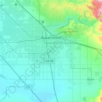
Name: Bakersfield topographic map, elevation, terrain.
Location: Bakersfield, Kern County, California, United States (35.19398 -119.26503 35.44730 -118.77234)
Average elevation: 157 m
Minimum elevation: 81 m
Maximum elevation: 915 m
Most of Bakersfield's major streets are six-lane divided roads with bike lanes, with almost every street in the city having proper lane signage for bicycle traffic. Bikes are a popular method of transportation in Bakersfield, due to the city's relatively flat topography and grid-like street system. Newer neighborhoods on the outskirts of the city, previously surrounded by two-lane farm roads, are prompting more large, divided roads to be built to help ease the increase in traffic that has resulted from an explosion in population. Many developers choose to widen the roads that connect these neighborhoods at their own discretion, which can cause a major road to widen and narrow repeatedly over a short distance (Allen Road and Panama Lane are prime examples of this). Since the Bakersfield city limit boundaries are not uniform and leap over different neighborhoods, this can cause Kern County "islands" to exist within Bakersfield. The county of Kern may choose not to upgrade a road while the city of Bakersfield does improve a road, which can cause traffic congestion to increase (Calloway Drive from the Westside Parkway north to Rosedale Highway best exemplifies this disparity).
Other topographic maps
Click on a map to view its topography, its elevation and its terrain.
Tehachapi
United States > California > Kern County
Tehachapi, Kern County, California, 93561, United States
Average elevation: 1,414 m
Mojave
United States > California > Kern County
Mojave, Kern County, California, United States
Average elevation: 857 m
Wasco
United States > California > Kern County
Wasco, Kern County, California, United States
Average elevation: 101 m
Cantil
United States > California > Kern County
Cantil, Kern County, California, United States
Average elevation: 628 m
Woodford
United States > California > Kern County
Woodford, El Rita, Kern County, California, 93531, United States
Average elevation: 899 m
City of Shafter
United States > California > Kern County
City of Shafter, Kern County, California, United States
Average elevation: 118 m
Tehachapi Mountain
United States > California > Kern County
Tehachapi Mountain, Kern County, California, United States
Average elevation: 2,142 m
Rosamond
United States > California > Kern County
Rosamond, Kern County, California, 93560, United States
Average elevation: 749 m
Baker
United States > California > Kern County > Boron
Baker, Boron, Kern County, California, United States
Average elevation: 765 m
Gulf
United States > California > Kern County
Gulf, Kern County, CAL Fire Contract Counties, California, United States
Average elevation: 88 m
Kern City
United States > California > Kern County > Bakersfield
Kern City, Bakersfield, Kern County, CAL Fire Southern Region, California, 93309, United States
Average elevation: 119 m
Golden Hills
United States > California > Kern County > Golden Hills
Golden Hills, Kern County, California, United States
Average elevation: 1,275 m
Onyx
United States > California > Kern County
Onyx, Kern County, California, 93255, United States
Average elevation: 1,205 m
Arvin
United States > California > Kern County
Arvin, Kern County, California, United States
Average elevation: 130 m
California City
United States > California > Kern County
California City, Kern County, California, United States
Average elevation: 845 m
Buttonwillow
United States > California > Kern County > Buttonwillow
Buttonwillow, Kern County, California, 93206, United States
Average elevation: 87 m
Rosedale
United States > California > Kern County
Rosedale, Kern County, CAL Fire Southern Region, California, United States
Average elevation: 107 m
Frazier Park
United States > California > Kern County
Frazier Park, Kern County, California, United States
Average elevation: 1,533 m
Oil City
United States > California > Kern County
Oil City, Kern River Oil Field, Kern County, California, 93305, United States
Average elevation: 162 m
Walong
United States > California > Kern County > Keene
Walong, Keene, Kern County, California, United States
Average elevation: 998 m
McKittrick
United States > California > Kern County
McKittrick, Kern County, California, 93251, United States
Average elevation: 388 m
Taft
United States > California > Kern County > Taft > Taft
Taft, Kern County, California, 93268, United States
Average elevation: 301 m
China Lake
United States > California > Kern County > Ridgecrest > China Lake
China Lake, Ridgecrest, Kern County, California, 93555-2508, United States
Average elevation: 689 m
Goler Heights
United States > California > Kern County > Goler Heights
Goler Heights, Kern County, California, United States
Average elevation: 822 m
Edison
United States > California > Kern County
Edison, Kern County, California, 93303, United States
Average elevation: 178 m
Taft
United States > California > Kern County
Taft, Kern County, California, 93268, United States
Average elevation: 370 m
Pine Mountain Club
United States > California > Kern County
Pine Mountain Club, Kern County, California, 93222, United States
Average elevation: 1,867 m
Rowen
United States > California > Kern County
Rowen, Kern County, California, 93531, United States
Average elevation: 806 m
Edwards Air Force Base
United States > California > Kern County
Edwards Air Force Base, Kern County, California, United States
Average elevation: 730 m
Lebec
United States > California > Kern County
Lebec, Kern County, California, 93243, United States
Average elevation: 1,162 m
Rosedale
United States > California > Kern County
Rosedale, Kern County, California, United States
Average elevation: 113 m
Inyokern
United States > California > Kern County > Inyokern
Inyokern, Kern County, California, United States
Average elevation: 753 m
Kernville
United States > California > Kern County
Kernville, Kern County, California, 93238, United States
Average elevation: 1,135 m