
Nyamata topographic map
Interactive map
Click on the map to display elevation.
About this map
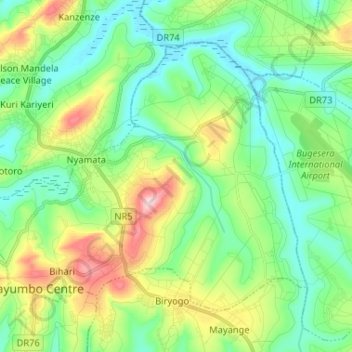
Name: Nyamata topographic map, elevation, terrain.
Location: Nyamata, Bugesera District, Eastern Province, Rwanda (-2.19907 30.04129 -2.09969 30.17113)
Average elevation: 1,420 m
Minimum elevation: 1,337 m
Maximum elevation: 1,616 m
Other topographic maps
Click on a map to view its topography, its elevation and its terrain.
Nyamata
Rwanda > Eastern Province > Bugesera District
Nyamata, Ntarama, Bugesera District, Eastern Province, Rwanda
Average elevation: 1,426 m
Mayange
Rwanda > Eastern Province > Bugesera District
Mayange, Bugesera District, Eastern Province, Rwanda
Average elevation: 1,416 m
Biryogo
Rwanda > Eastern Province > Bugesera District
Biryogo, Mayange, Bugesera District, Eastern Province, Rwanda
Average elevation: 1,448 m
Rilima
Rwanda > Eastern Province > Bugesera District
Rilima, Bugesera District, Eastern Province, Rwanda
Average elevation: 1,379 m