
Rilima topographic map
Interactive map
Click on the map to display elevation.
About this map
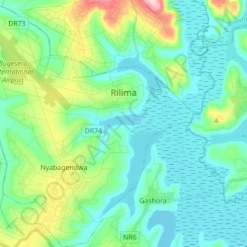
Name: Rilima topographic map, elevation, terrain.
Location: Rilima, Bugesera District, Eastern Province, Rwanda (-2.23157 30.14717 -2.10983 30.26389)
Average elevation: 1,379 m
Minimum elevation: 1,324 m
Maximum elevation: 1,572 m
Rilima is located in Bugesera District, Eastern Province, south of Kigali, the national capital and the largest city in the country. Its location is about 42.5 kilometres (26.4 mi), by road, south of Kigali. The geographical coordinates of Rilima are:02°09'35.0"S, 30°13'31.0"E (Latitude:-2.159722; Longitude:30.225278). Rilima is situated at an altitude of 1,394 metres (4,573 ft) above sea level.
Other topographic maps
Click on a map to view its topography, its elevation and its terrain.
Nyamata
Rwanda > Eastern Province > Bugesera District
Nyamata, Ntarama, Bugesera District, Eastern Province, Rwanda
Average elevation: 1,426 m
Mayange
Rwanda > Eastern Province > Bugesera District
Mayange, Bugesera District, Eastern Province, Rwanda
Average elevation: 1,416 m
Biryogo
Rwanda > Eastern Province > Bugesera District
Biryogo, Mayange, Bugesera District, Eastern Province, Rwanda
Average elevation: 1,448 m
Nyamata
Rwanda > Eastern Province > Bugesera District
Nyamata, Bugesera District, Eastern Province, Rwanda
Average elevation: 1,420 m