
Mayange topographic map
Interactive map
Click on the map to display elevation.
About this map
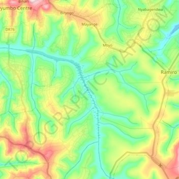
Name: Mayange topographic map, elevation, terrain.
Location: Mayange, Bugesera District, Eastern Province, Rwanda (-2.35067 30.08875 -2.18335 30.21998)
Average elevation: 1,416 m
Minimum elevation: 1,328 m
Maximum elevation: 1,580 m
Other topographic maps
Click on a map to view its topography, its elevation and its terrain.
Rilima
Rwanda > Eastern Province > Bugesera District
Rilima is located in Bugesera District, Eastern Province, south of Kigali, the national capital and the largest city in the country. Its location is about 42.5 kilometres (26.4 mi), by road, south of Kigali. The geographical coordinates of Rilima are:02°09'35.0"S, 30°13'31.0"E (Latitude:-2.159722;…
Average elevation: 1,379 m