

Brandenburg topographic map
Click on the map to display elevation.
About this map
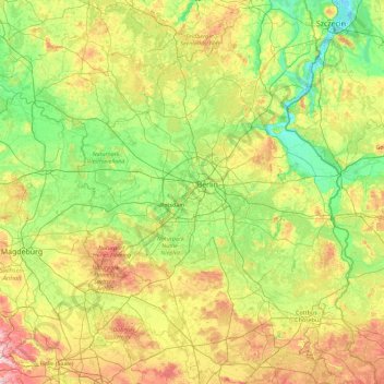
Name: Brandenburg topographic map, elevation, terrain.
Location: Brandenburg, Germany (51.35906 11.26577 53.55909 14.76582)
Average elevation: 68 m
Minimum elevation: -2 m
Maximum elevation: 314 m
Other topographic maps
Click on a map to view its topography, its elevation and its terrain.
Berlin
Berlin straddles the banks of the River Spree, which flows into the River Havel (a tributary of the River Elbe) in the western borough of Spandau. Among the city's main topographical features are the many lakes in the western and southeastern boroughs formed by the Spree, Havel, and Dahme rivers (the largest…
Average elevation: 47 m
Hamburg
The neighborhoods of Neuenfelde, Cranz, Francop and Finkenwerder are part of the Altes Land (old land) region, the largest contiguous fruit-producing region in Central Europe. Neugraben-Fischbek has Hamburg's highest elevation, the Hasselbrack at 116.2 metres (381 ft) AMSL. Hamburg borders the states of…
Average elevation: 23 m


Sirnitz
Germany > Baden-Württemberg > Landkreis Breisgau-Hochschwarzwald > Müllheim im Markgräflerland
Average elevation: 949 m
Stuttgart
Germany > Baden-Württemberg > Stuttgart
Stuttgart covers an area of 207.35 km2 (80 sq mi) and sits at elevation ranging from 207 m (679 ft) above sea level by the Neckar river to 549 m (1,801 ft) on Bernhartshöhe hill – something rather unique in large German cities. The most prominent elevated locales in Stuttgart are the Birkenkopf (511 m…
Average elevation: 353 m
Hamburg
The neighborhoods of Neuenfelde, Cranz, Francop and Finkenwerder are part of the Altes Land (old land) region, the largest contiguous fruit-producing region in Central Europe. Neugraben-Fischbek has Hamburg's highest elevation, the Hasselbrack at 116.2 metres (381 ft) AMSL. Hamburg borders the states of…
Average elevation: 56 m
Neuschwanstein Castle
Germany > Bavaria > Landkreis Ostallgäu > Schwangau > Hohenschwangau
The municipality of Schwangau lies at an elevation of 800 m (2,620 ft) at the southwest border of the German state of Bavaria. Its surroundings are characterised by the transition between the Alpine foothills in the south (toward the nearby Austrian border) and a hilly landscape in the north that appears flat…
Average elevation: 982 m

Wohnsiedlung Am Flugplatz
Germany > Thuringia > Unstrut-Hainich-Kreis > Obermehler
Average elevation: 269 m


Klein-Netterden
Germany > North Rhine-Westphalia > Kreis Kleve > Emmerich on the Rhine
Average elevation: 17 m



Heligoland
Germany > Schleswig-Holstein > Kreis Pinneberg > Helgoland > Helgoland
Average elevation: 2 m

Rohden
Germany > Lower Saxony > Landkreis Hameln-Pyrmont > Hessisch Oldendorf
Average elevation: 149 m

Weiherkopf
Germany > Bavaria > Landkreis Oberallgäu > Bolsterlang
In 18th century maps the mountain is described as the Veier; but, from 1940, in the topographical map of Fischen as the Weiher Kopf. "A pond [Weiher] from which the name might have been derived can no longer be identified". Steiner believes it is, however, entirely plausible that the mountain might once have…
Average elevation: 1,374 m
Zugspitze
Germany > Bavaria > Landkreis Garmisch-Partenkirchen > Grainau
The mountain rises eleven kilometres southwest of Garmisch-Partenkirchen and just under six kilometres east of Ehrwald. The border between Germany and Austria runs over the west summit; thus the Zugspitze massif belongs to the German state of Bavaria and the Austrian state of Tyrol. The municipalities…
Average elevation: 2,300 m


Schallberg
Germany > Baden-Württemberg > Landkreis Böblingen > Weil der Stadt
Average elevation: 416 m

Marxhagen
Germany > Mecklenburg-Vorpommern > Mecklenburgische Seenplatte > Moltzow
Average elevation: 87 m
Neuschwanstein Castle
Germany > Bavaria > Landkreis Ostallgäu > Hohenschwangau
The municipality of Schwangau lies at an elevation of 800 m (2,620 ft) at the southwest border of the German state of Bavaria. Its surroundings are characterised by the transition between the Alpine foothills in the south (toward the nearby Austrian border) and a hilly landscape in the north that appears flat…
Average elevation: 982 m

Nettelrede
Germany > Lower Saxony > Landkreis Hameln-Pyrmont > Bad Münder am Deister
Average elevation: 177 m

Streckelsberg
Germany > Mecklenburg-Vorpommern > Vorpommern-Greifswald > Koserow
Average elevation: 3 m


Wuppertal
Germany > North Rhine-Westphalia > Wuppertal
Uniquely for Germany, it is a "linear city", owing to the steep hillsides along the river Wupper. Its highest hill is the Lichtscheid, which is 351 metres above sea level. The dominant urban centres Elberfeld (historic commercial centre) and Barmen (more industrial) have formed a continuous urbanized area…
Average elevation: 209 m




Spornhof
Germany > Bavaria > Landkreis Berchtesgadener Land > Berchtesgaden > Unterau
Average elevation: 814 m
Bochum
Germany > North Rhine-Westphalia > Bochum
The city lies on the low rolling hills of Bochum land ridge (Bochumer Landrücken), part of the Ruhrhöhen (highest elevations) between the Ruhr and Emscher rivers at the border of the southern and northern Ruhr coal region. The highest point of the city is at Kemnader Straße (Kemnader Street) in Stiepel at…
Average elevation: 107 m




Eifel
Germany > Rhineland-Palatinate > Landkreis Ahrweiler > Adenau
The Eifel is in the Atlantic climate zone with its relatively high precipitation; winters that are moderately cold and long with periods of snow; and summers that are often humid and cool. The prevailing wind is west/southwest. A relatively dry and milder climate prevails in the wind and rain shadow of the…
Average elevation: 585 m

Neander Valley;Neandertal Valley
Germany > North Rhine-Westphalia > Kreis Mettmann > Mettmann
Average elevation: 118 m



Recklinghausen (Sauerland)
Germany > North Rhine-Westphalia > Hochsauerlandkreis > Sundern
Average elevation: 332 m

Jena
Jena is situated in a hilly landscape in eastern Thuringia at the Saale river, between the Harz mountains 85 km (53 mi) in the north, the Thuringian Forest/Thuringian Highland 50 km (31 mi) in the southwest and the Ore Mountains, 75 km (47 mi) in the southeast. The municipal terrain is hilly with rugged slopes…
Average elevation: 289 m

Andelshofen
Germany > Baden-Württemberg > Lake Constance district > Überlingen
Average elevation: 482 m


Partnach Gorge
Germany > Bavaria > Landkreis Garmisch-Partenkirchen > Garmisch-Partenkirchen > Vordergraseck
Average elevation: 1,003 m

Erlangen
In 1435 the church, which had been the daughter church of St. Martin in Forchheim up until this point, was elevated to its own parish. The main task of the Erlangen priest was the pastoral care in the city of Erlangen and the St. Martin's Chapel on the Martinsbühl, which was now named for the first time.…
Average elevation: 331 m

Ore Mountains
The higher altitudes from around 500 m above sea level on the German side belong to the Ore Mountains/Vogtland Nature Park – the largest of its kind in Germany with a length of 120 km. The eastern Ore Mountains are protected landscape. Other smaller areas on the German and Czech sides are protected as nature…
Average elevation: 443 m

Neu Darbein
Germany > Mecklenburg-Vorpommern > Mecklenburgische Seenplatte > Dargun
Average elevation: 26 m
Potsdam
Germany > Brandenburg > Potsdam
The traditional towns in the governorate were small, however, in the course of the industrial labour migration some reached the rank of urban districts. The principal towns were Brandenburg upon Havel, Köpenick, Potsdam, Prenzlau, Spandau and Ruppin. Until 1875 Berlin also was a town within the governorate.…
Average elevation: 43 m
Obersalzberg
Germany > Bavaria > Landkreis Berchtesgadener Land > Berchtesgaden
Average elevation: 933 m

Stockerbichl
Germany > Bavaria > Landkreis Starnberg > Tutzing > Unterzeismering
Average elevation: 634 m

Lidorf
Germany > Bavaria > Landkreis Rottal-Inn > Mitterskirchen > Mitterskirchen
Average elevation: 458 m
Blauen
Germany > Baden-Württemberg > Landkreis Lörrach
In the 14th century, the mountain was recorded as the Blauwen or Blawen. Matthäus Merian's Topographia Sueviae in the mid-17th century calls it the Hoche Blawen ("High Blawen"). The parish boundary plan of the first Baden state survey of 1769/1770 distinguishes between the Hoch Blauen ("High Blauen") and the…
Average elevation: 877 m

Wiesbaden
The highest point of the Wiesbaden municipality is located northwest of the city center near the summit of the Hohe Wurzel, with an elevation of 608 metres (1,995 ft) above sea level. The lowest point is the harbour entrance of Schierstein at 83 metres (272 ft) above sea level. The central square (the…
Average elevation: 258 m
Heligoland
Germany > Schleswig-Holstein > Kreis Pinneberg > Helgoland > Helgoland
Average elevation: 2 m


Immenstadt im Allgäu
Germany > Bavaria > Landkreis Oberallgäu > Immenstadt im Allgäu
Average elevation: 910 m

Neuschwanstein Castle
Germany > Bavaria > Landkreis Ostallgäu > Hohenschwangau
The municipality of Schwangau lies at an elevation of 800 m (2,620 ft) at the southwest border of the German state of Bavaria. Its surroundings are characterised by the transition between the Alpine foothills in the south (toward the nearby Austrian border) and a hilly landscape in the north that appears flat…
Average elevation: 982 m
