
Make a donation
Gear up for your next adventure:
As an Amazon Associate, this site earns from qualifying purchases at no extra cost to you.
Hamburg topographic map
Click on the map to display elevation.
Make a donation
Gear up for your next adventure:
As an Amazon Associate, this site earns from qualifying purchases at no extra cost to you.
Hamburg
The neighborhoods of Neuenfelde, Cranz, Francop and Finkenwerder are part of the Altes Land (old land) region, the largest contiguous fruit-producing region in Central Europe. Neugraben-Fischbek has Hamburg's highest elevation, the Hasselbrack at 116.2 metres (381 ft) AMSL. Hamburg borders the states of Schleswig-Holstein and Lower Saxony.
Make a donation
Gear up for your next adventure:
As an Amazon Associate, this site earns from qualifying purchases at no extra cost to you.
About this map
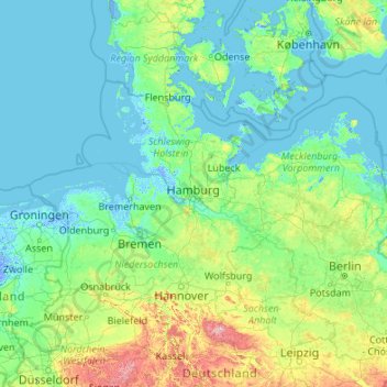
Name: Hamburg topographic map, elevation, terrain.
Location: Hamburg, Germany (50.94376 7.40991 56.14376 12.60991)
Average elevation: 56 m
Minimum elevation: -5 m
Maximum elevation: 999 m
Make a donation
Gear up for your next adventure:
As an Amazon Associate, this site earns from qualifying purchases at no extra cost to you.
Other topographic maps
Click on a map to view its topography, its elevation and its terrain.
Munich
Munich lies on the elevated plains of Upper Bavaria, about 50 km (31 mi) north of the northern edge of the Alps, at an altitude of about 520 m (1,706 ft) ASL. The local rivers are the Isar and the Würm. Munich is situated in the Northern Alpine Foreland. The northern part of this sandy plateau includes a…
Average elevation: 524 m
Nürburg
Germany > Rhineland-Palatinate > Landkreis Ahrweiler
Nürburg has a semi-continental climate with both oceanic and continental tendencies. It does however land in the former category (Köppen Cfb). With regards to the racetrack, due to the Nordschleife's varied terrain and elevation, weather may be completely different on either end of the track. The elevation…
Average elevation: 560 m
Berlin
Berlin straddles the banks of the Spree, which flows into the Havel (a tributary of the Elbe) in the western borough of Spandau. Among the city's main topographical features are the many lakes in the western and southeastern boroughs formed by the Spree, Havel and Dahme, the largest of which is Lake…
Average elevation: 48 m
Munich
Munich lies on the elevated plains of Upper Bavaria, about 50 km (31 mi) north of the northern edge of the Alps, at an altitude of about 520 m (1,706 ft) ASL. The local rivers are the Isar and the Würm. Munich is situated in the Northern Alpine Foreland. The northern part of this sandy plateau includes a…
Average elevation: 524 m
Make a donation
Gear up for your next adventure:
As an Amazon Associate, this site earns from qualifying purchases at no extra cost to you.
Karlsruhe
The city lies at an altitude between 100 and 322 m (near the communications tower in the suburb of Grünwettersbach). Its geographical coordinates are 49°00′N 8°24′E / 49.000°N 8.400°E / 49.000; 8.400; the 49th parallel runs through the city centre, which puts it at the same latitude as much…
Average elevation: 132 m
Baden-Württemberg
The climate across the states varies. This is mostly due to a high amount of mountains and highlands inside of the state. Most parts in the western parts (Baden) lower than 500–800 metres (1,600–2,600 ft) enjoy an almost year round mild oceanic climate (cfb in Köppen classification). The climate in the…
Average elevation: 442 m
Aachen
Germany > North Rhine-Westphalia > Aachen (district)
The maximum dimensions of the city's territory are 21.6 km (13+3⁄8 mi) from north to south, and 17.2 km (10+3⁄4 mi) from east to west. The city limits are 87.7 km (54+1⁄2 mi) long, of which 23.8 km (14+3⁄4 mi) border Belgium and 21.8 km (13+1⁄2 mi) the Netherlands. The highest point in Aachen,…
Average elevation: 225 m
Garmisch-Partenkirchen
Germany > Bavaria > Landkreis Garmisch-Partenkirchen
Garmisch-Partenkirchen leans towards an oceanic climate, and its winters are colder than the rest of Bavaria. Due to its higher elevation, it is very close to the winters associated with continental climates; it has a relatively wet and snowy climate, with high precipitation year-round.
Average elevation: 1,326 m
Make a donation
Gear up for your next adventure:
As an Amazon Associate, this site earns from qualifying purchases at no extra cost to you.
Hamburg
The neighborhoods of Neuenfelde, Cranz, Francop and Finkenwerder are part of the Altes Land (old land) region, the largest contiguous fruit-producing region in Central Europe. Neugraben-Fischbek has Hamburg's highest elevation, the Hasselbrack at 116.2 metres (381 ft) AMSL. Hamburg borders the states of…
Average elevation: 27 m
Berlin
Berlin straddles the banks of the Spree, which flows into the Havel (a tributary of the Elbe) in the western borough of Spandau. Among the city's main topographical features are the many lakes in the western and southeastern boroughs formed by the Spree, Havel and Dahme, the largest of which is Lake…
Average elevation: 48 m
Make a donation
Gear up for your next adventure:
As an Amazon Associate, this site earns from qualifying purchases at no extra cost to you.
Elbe
The Elbe (Labe) rises on the slopes of Mt. Violík at an elevation of 1,386 metres (4,547 ft) in the Giant Mountains on the northwest borders of the Czech Republic. Of the numerous small streams whose waters compose the infant river. After plunging down the 30 metres (98 ft) of the Elbe Falls, the latter…
Average elevation: 179 m
Föhr
Germany > Schleswig-Holstein > Northern Friesland
Föhr is called "The Green Island" due to being sheltered from the storms of the North Sea by its neighbouring islands Sylt and Amrum, so that Föhr's vegetation is thriving compared to that of the other islands. It is 6.8 kilometres wide and 12 km long; the surface measures 82.82 km2. While the northern parts…
Average elevation: 1 m
Make a donation
Gear up for your next adventure:
As an Amazon Associate, this site earns from qualifying purchases at no extra cost to you.
Nuremberg
Nuremberg has an oceanic climate (Köppen Cfb) with a certain humid continental influence (Dfb), categorized in the latter by the 0 °C isotherm. The city's climate is influenced by its inland position and higher altitude. Winters are changeable, with either mild or cold weather: the average temperature is…
Average elevation: 336 m
Saxony
The Ore Mountains in southern Saxony are traditionally a region of winter sports. The ski ressort of Oberwiesenthal is the highest town of Germany, at an altitude of 900 m, though the surrounding mountains do not reach the same height as in the alpine areas of Southern Germany. Thus, climate change is posing a…
Average elevation: 290 m
Make a donation
Gear up for your next adventure:
As an Amazon Associate, this site earns from qualifying purchases at no extra cost to you.
Black Forest
Its highest peak is the Feldberg with an elevation of 1,493 metres (4,898 ft) above sea level. Roughly oblong in shape, with a length of 160 kilometres (100 miles) and breadth of up to 50 km (30 mi), it has an area of about 6,009 km2 (2,320 sq mi).
Average elevation: 471 m
Make a donation
Gear up for your next adventure:
As an Amazon Associate, this site earns from qualifying purchases at no extra cost to you.
Laupheim
Germany > Baden-Württemberg > Landkreis Biberach
The elevation within the city confines ranges from 509 m (1670 ft) above sea level at the bottom of the valley to 539 m (1768 ft) in the outlying suburban areas.
Average elevation: 523 m
Minden
Germany > North Rhine-Westphalia > Kreis Minden-Lübbecke
The Weser leaves the Minden area at its lowest part in the quarter of Leteln, at 40 metres (131 feet), while the highest part is the top of Häverstädter Berg with 272 metres (892 feet), at the edge of the Wiehen Hills in the quarter of Haddenhausen. The altitude of the town is given officially as 42.2 metres…
Average elevation: 60 m
Make a donation
Gear up for your next adventure:
As an Amazon Associate, this site earns from qualifying purchases at no extra cost to you.
83646
Germany > Bavaria > Landkreis Bad Tölz-Wolfratshausen > Oberfischbach > Sauersberg
Average elevation: 779 m
Munich
Munich lies on the elevated plains of Upper Bavaria, about 50 km (31 mi) north of the northern edge of the Alps, at an altitude of about 520 m (1,706 ft) ASL. The local rivers are the Isar and the Würm. Munich is situated in the Northern Alpine Foreland. The northern part of this sandy plateau includes a…
Average elevation: 524 m
Make a donation
Gear up for your next adventure:
As an Amazon Associate, this site earns from qualifying purchases at no extra cost to you.
Rügen
Germany > Mecklenburg-Vorpommern
Rügen has a total area of 926.4 km2 (357.7 sq mi), or 974 km2 (376 sq mi) if the adjacent small islands are included. The maximum diameter is 51.4 km (31.9 mi) from north to south, and 42.8 km (26.6 mi) from east to west. Of an overall 574 km (357 mi)-long coastline, 56 km (35 mi) are sandy Baltic Sea…
Average elevation: 7 m
Make a donation
Gear up for your next adventure:
As an Amazon Associate, this site earns from qualifying purchases at no extra cost to you.
Make a donation
Gear up for your next adventure:
As an Amazon Associate, this site earns from qualifying purchases at no extra cost to you.
Schleswig-Holstein
The Baltic Sea coast in the east of Schleswig-Holstein is marked by bays, fjords, and cliff lines. Rolling hills (the highest elevation is the Bungsberg at 168 metres or 551 feet) and many lakes are found, especially in the eastern part of Holstein called the Holstein Switzerland and the former Duchy of…
Average elevation: 17 m
Make a donation
Gear up for your next adventure:
As an Amazon Associate, this site earns from qualifying purchases at no extra cost to you.
Nuremberg
Nuremberg has an oceanic climate (Köppen Cfb) with a certain humid continental influence (Dfb), categorized in the latter by the 0 °C isotherm. The city's climate is influenced by its inland position and higher altitude. Winters are changeable, with either mild or cold weather: the average temperature is…
Average elevation: 336 m
Hanover
Germany > Lower Saxony > Region Hannover
In 1636 George, Duke of Brunswick-Lüneburg, ruler of the Brunswick-Lüneburg principality of Calenberg, moved his residence to Hanover. The Dukes of Brunswick-Lüneburg were elevated by the Holy Roman Emperor to the rank of Prince-Elector in 1692 and this elevation was confirmed by the Imperial Diet in 1708.…
Average elevation: 61 m
Make a donation
Gear up for your next adventure:
As an Amazon Associate, this site earns from qualifying purchases at no extra cost to you.
Make a donation
Gear up for your next adventure:
As an Amazon Associate, this site earns from qualifying purchases at no extra cost to you.
Make a donation
Gear up for your next adventure:
As an Amazon Associate, this site earns from qualifying purchases at no extra cost to you.
Make a donation
Gear up for your next adventure:
As an Amazon Associate, this site earns from qualifying purchases at no extra cost to you.
Wiesbaden
The highest point of the Wiesbaden municipality is located northwest of the city center near the summit of the Hohe Wurzel, with an elevation of 608 metres (1,995 ft) above sea level. The lowest point is the harbour entrance of Schierstein at 83 metres (272 ft) above sea level. The central square (the…
Average elevation: 221 m
Harz
The Harz (German: [haːɐ̯ts] (listen)) is a highland area in northern Germany. It has the highest elevations for that region, and its rugged terrain extends across parts of Lower Saxony, Saxony-Anhalt, and Thuringia. The name Harz derives from the Middle High German word Hardt or Hart (hill forest). The name…
Average elevation: 280 m
Make a donation
Gear up for your next adventure:
As an Amazon Associate, this site earns from qualifying purchases at no extra cost to you.
Essen
Germany > North Rhine-Westphalia
The lowest point can be found in the northern borough of Karnap at 26.5 m (86.9 ft), the highest point in the borough of Heidhausen at 202.5 m (664 ft). The average elevation is 116 m (381 ft).
Average elevation: 86 m
Make a donation
Gear up for your next adventure:
As an Amazon Associate, this site earns from qualifying purchases at no extra cost to you.
Erlangen
In 1435 the church, which had been the daughter church of St. Martin in Forchheim up until this point, was elevated to its own parish. The main task of the Erlangen priest was the pastoral care in the city of Erlangen and the St. Martin's Chapel on the Martinsbühl, which was now named for the first time.…
Average elevation: 300 m
Ore Mountains
The higher altitudes from around 500 m above sea level on the German side belong to the Ore Mountains/Vogtland Nature Park – the largest of its kind in Germany with a length of 120 km. The eastern Ore Mountains are protected landscape. Other smaller areas on the German and Czech sides are protected as nature…
Average elevation: 443 m
Make a donation
Gear up for your next adventure:
As an Amazon Associate, this site earns from qualifying purchases at no extra cost to you.
Make a donation
Gear up for your next adventure:
As an Amazon Associate, this site earns from qualifying purchases at no extra cost to you.
Hesse
Oculus Optikgeräte manufactures Scheimpflug tomographs for examining the anterior segment of the eye, topographers for measuring the anterior surface of the cornea, tonometers for assessing the biomechanical properties of the cornea, a wide-angle observation system for vitreous body surgery, universal trial…
Average elevation: 313 m
Karlsruhe
The city lies at an altitude of between 100 and 322 m (328 and 1,056 ft), the higher figure being near the communications tower in the suburb of Grünwettersbach. Its geographical coordinates are 49°00′N 8°24′E / 49.000°N 8.400°E / 49.000; 8.400; the 49th parallel runs through the city centre,…
Average elevation: 132 m
Gera
Gera is located in a smooth-hilly landscape in eastern Thuringia at the White Elster river (progression: Saale→ Elbe→ North Sea), between the Thuringian Highland approx. 50 km (31 mi) in the south-west, the Ore Mountains approx. 50 km (31 mi) in the south-east and the Leipzig Bay approx. 50 km (31 mi) in…
Average elevation: 278 m
Make a donation
Gear up for your next adventure:
As an Amazon Associate, this site earns from qualifying purchases at no extra cost to you.
Ulm
Ulm lies at the point where the rivers Blau and Iller join the Danube, at an altitude of 479 m (1,571.52 ft) above sea level. Most parts of the city, including the old town, are situated on the northern bank of the Danube; only the districts of Wiblingen, Gögglingen, Donaustetten and Unterweiler lie on the…
Average elevation: 518 m
Essen
Germany > North Rhine-Westphalia
The lowest point can be found in the northern borough of Karnap at 26.5 metres (86.9 ft), the highest point in the borough of Heidhausen at 202.5 metres (664 ft). The average elevation is 116 metres (381 ft).
Average elevation: 86 m
Make a donation
Gear up for your next adventure:
As an Amazon Associate, this site earns from qualifying purchases at no extra cost to you.
Aachen
Germany > North Rhine-Westphalia > Städteregion Aachen
The maximum dimensions of the city's territory are 21.6 km (13+3⁄8 mi) from north to south, and 17.2 km (10+3⁄4 mi) from east to west. The city limits are 87.7 km (54+1⁄2 mi) long, of which 23.8 km (14+3⁄4 mi) border Belgium and 21.8 km (13+1⁄2 mi) the Netherlands. The highest point in Aachen,…
Average elevation: 225 m
Wiesbaden
The highest point of the Wiesbaden municipality is located northwest of the city center near the summit of the Hohe Wurzel, with an elevation of 608 metres (1,995 ft) above sea level. The lowest point is the harbour entrance of Schierstein at 83 metres (272 ft) above sea level. The central square (the…
Average elevation: 221 m
Make a donation
Gear up for your next adventure:
As an Amazon Associate, this site earns from qualifying purchases at no extra cost to you.
Neuschwanstein Castle
Germany > Bavaria > Landkreis Ostallgäu > Hohenschwangau
The municipality of Schwangau lies at an elevation of 800 m (2,620 ft) at the southwest border of the German state of Bavaria. Its surroundings are characterised by the transition between the Alpine foothills in the south (toward the nearby Austrian border) and a hilly landscape in the north that appears flat…
Average elevation: 982 m
Weimar
Weimar is situated within the valley of Ilm river, a tributary of Saale river on the southern border of the Thuringian Basin, a fertile agricultural area between the Harz mountains 70 km (43 mi) in the north and the Thuringian Forest 50 km (31 mi) in the southwest. The municipal terrain is hilly; the height of…
Average elevation: 299 m
Make a donation
Gear up for your next adventure:
As an Amazon Associate, this site earns from qualifying purchases at no extra cost to you.
Mainz
Germany > Rhineland-Palatinate
Nevertheless, the post-war reconstruction took place very slowly. While cities such as Frankfurt had been rebuilt fast by a central authority, only individual efforts were initially successful in rebuilding Mainz. The reason for this was that the French wanted Mainz to expand and become a model city. Mainz lay…
Average elevation: 132 m
Make a donation
Gear up for your next adventure:
As an Amazon Associate, this site earns from qualifying purchases at no extra cost to you.
Albbruck
Germany > Baden-Württemberg > Landkreis Waldshut
The municipality is crossed by the chine valleys of the Mühlbach and Alb rivers. The valley [de] of the former is a Federally-protected nature reserve and the latter forms part of the municipality's northwest border. Elevation above sea level in the municipal area ranges from a high of 729 meters (2,392 ft)…
Average elevation: 534 m
Make a donation
Gear up for your next adventure:
As an Amazon Associate, this site earns from qualifying purchases at no extra cost to you.