
North Rhine-Westphalia topographic map
Interactive map
Click on the map to display elevation.
About this map
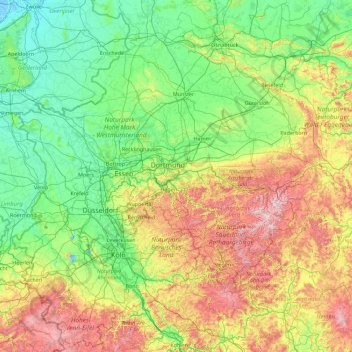
Name: North Rhine-Westphalia topographic map, elevation, terrain.
Location: North Rhine-Westphalia, Germany (50.32269 5.86632 52.53149 9.46174)
Average elevation: 180 m
Minimum elevation: -4 m
Maximum elevation: 842 m
Other topographic maps
Click on a map to view its topography, its elevation and its terrain.
Berlin
Berlin straddles the banks of the River Spree, which flows into the River Havel (a tributary of the River Elbe) in the western borough of Spandau. Among the city's main topographical features are the many lakes in the western and southeastern boroughs formed by the Spree, Havel, and Dahme rivers (the largest…
Average elevation: 47 m
Stuttgart
Germany > Baden-Württemberg > Stuttgart
Stuttgart covers an area of 207.35 km2 (80 sq mi) and sits at elevation ranging from 207 m (679 ft) above sea level by the Neckar river to 549 m (1,801 ft) on Bernhartshöhe hill – something rather unique in large German cities. The most prominent elevated locales in Stuttgart are the Birkenkopf (511 m…
Average elevation: 353 m
Schönenberg
Germany > Rhineland-Palatinate > Landkreis Kusel > Schönenberg-Kübelberg
Average elevation: 266 m
Aachen
Germany > North Rhine-Westphalia > Städteregion Aachen
The maximum dimensions of the city's territory are 21.6 km (13+3⁄8 mi) from north to south, and 17.2 km (10+3⁄4 mi) from east to west. The city limits are 87.7 km (54+1⁄2 mi) long, of which 23.8 km (14+3⁄4 mi) border Belgium and 21.8 km (13+1⁄2 mi) the Netherlands. The highest point in Aachen,…
Average elevation: 225 m
Munich
Munich lies on the elevated plains of Upper Bavaria, about 50 km (31 mi) north of the northern edge of the Alps, at an altitude of about 520 m (1,706 ft) ASL. The local rivers are the Isar and the Würm. Munich is situated in the Northern Alpine Foreland. The northern part of this sandy plateau includes a…
Average elevation: 524 m
Berlin
Berlin straddles the banks of the Spree, which flows into the Havel (a tributary of the Elbe) in the western borough of Spandau. Among the city's main topographical features are the many lakes in the western and southeastern boroughs formed by the Spree, Havel and Dahme, the largest of which is Lake…
Average elevation: 48 m
Black Forest
Its highest peak is the Feldberg with an elevation of 1,493 metres (4,898 ft) above sea level. Roughly oblong in shape, with a length of 160 kilometres (100 miles) and breadth of up to 50 km (30 mi), it has an area of about 6,009 km2 (2,320 sq mi).
Average elevation: 471 m
Nuremberg
Nuremberg has an oceanic climate (Köppen Cfb) with a certain humid continental influence (Dfb), categorized in the latter by the 0 °C isotherm. The city's climate is influenced by its inland position and higher altitude. Winters are changeable, with either mild or cold weather: the average temperature is…
Average elevation: 336 m
Hamburg
The neighborhoods of Neuenfelde, Cranz, Francop and Finkenwerder are part of the Altes Land (old land) region, the largest contiguous fruit-producing region in Central Europe. Neugraben-Fischbek has Hamburg's highest elevation, the Hasselbrack at 116.2 metres (381 ft) AMSL. Hamburg borders the states of…
Average elevation: 23 m
Baden-Württemberg
The climate across the states varies. This is mostly due to a high amount of mountains and highlands inside of the state. Most parts in the western parts (Baden) lower than 500–800 metres (1,600–2,600 ft) enjoy an almost year round mild oceanic climate (cfb in Köppen classification). The climate in the…
Average elevation: 442 m
Freiberg
Germany > Saxony > Mittelsachsen
The town lies on the northern declivity of the Ore Mountains, with the majority of the borough west of the Eastern or Freiberger Mulde river. Parts of the town are nestled in the valleys of Münzbach and Goldbach streams. Its centre has an altitude of about 412 m above sea level (NHN) (at the railway station).…
Average elevation: 405 m
Hamburg
The neighborhoods of Neuenfelde, Cranz, Francop and Finkenwerder are part of the Altes Land (old land) region, the largest contiguous fruit-producing region in Central Europe. Neugraben-Fischbek has Hamburg's highest elevation, the Hasselbrack at 116.2 metres (381 ft) AMSL. Hamburg borders the states of…
Average elevation: 27 m
Reiferscheid
Germany > Rhineland-Palatinate > Landkreis Altenkirchen (Westerwald)
Average elevation: 240 m
5er-Grube
Germany > Bavaria > Landkreis Starnberg > Krailling > Kraillinger Innovations Meile KIM
Average elevation: 562 m
Ottenbach
Germany > Baden-Württemberg > Landkreis Göppingen
Cycling: Nationally known is Ottenbach for the organization and conduct of mass sports bike marathon "Alb-extreme". The itinerary leads annually on the last Sunday in June over a distance of 190, 210 and 260 km through the countryside of the Swabian Jura with many elevations.
Average elevation: 449 m
Nürburg
Germany > Rhineland-Palatinate > Landkreis Ahrweiler
Nürburg has a semi-continental climate with both oceanic and continental tendencies. It does however land in the former category (Köppen Cfb). With regards to the racetrack, due to the Nordschleife's varied terrain and elevation, weather may be completely different on either end of the track. The elevation…
Average elevation: 560 m
Meinerzhagen
Germany > North Rhine-Westphalia > Märkischer Kreis
Meinerzhagen is located in the hills of the Sauerland. The highest elevation is the Nordhelle with 652 m above sea level, the lowest elevation at the Lister dam with 319m. 56% of the town area is covered by forests.
Average elevation: 419 m
Albbruck
Germany > Baden-Württemberg > Landkreis Waldshut
The municipality is crossed by the chine valleys of the Mühlbach and Alb rivers. The valley [de] of the former is a Federally-protected nature reserve and the latter forms part of the municipality's northwest border. Elevation above sea level in the municipal area ranges from a high of 729 meters (2,392 ft)…
Average elevation: 534 m
Reichelsheim (Odenwald)
Germany > Hesse > Odenwaldkreis
Reichelsheim lies in the middle Odenwald at elevations between 200 and 538 m in the middle of the Geo-Naturpark Bergstraße-Odenwald.
Average elevation: 335 m
Schüttorf
Germany > Lower Saxony > Landkreis Grafschaft Bentheim
The town of Schüttorf lies mainly on valley sand plates which are crossed by the Vechte Lowland, which is almost flush with them along this stretch. The lowland lies roughly 30 m above sea level and is from 200 to 500 m wide. Bordering its edges are river terraces with a height of roughly 35 m above sea…
Average elevation: 39 m
Marktheidenfeld
Germany > Bavaria > Landkreis Main-Spessart > Marktheidenfeld
Average elevation: 211 m
Hochstadt (Pfalz)
Germany > Rhineland-Palatinate > Landkreis Südliche Weinstraße
Average elevation: 133 m
Neumarkt in der Oberpfalz
Germany > Bavaria > Landkreis Neumarkt in der Oberpfalz
Neumarkt lies on the western edge of the Franconian Jura, nestled in a valley. The municipal region reaches as far as the Bavarian Jura to the east. The Neumarkt valley drains to the north through the Schwarzach River, a tributary of the Regnitz, eventually flowing into the Main, and to the south through the…
Average elevation: 479 m
Markt Erlbach
Germany > Bavaria > Landkreis Neustadt an der Aisch-Bad Windsheim
Average elevation: 378 m