
جرجرة topographic map
Interactive map
Click on the map to display elevation.
About this map
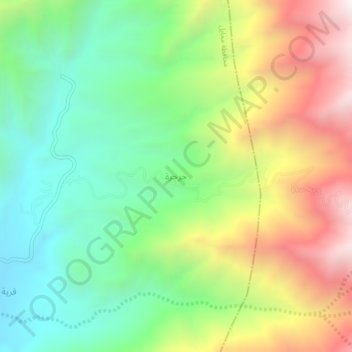
Name: جرجرة topographic map, elevation, terrain.
Location: جرجرة, محافظة محايل, Asir, Arabie saoudite (18.64232 42.17557 18.68232 42.21557)
Average elevation: 1,531 m
Minimum elevation: 979 m
Maximum elevation: 2,382 m
Other topographic maps
Click on a map to view its topography, its elevation and its terrain.
Um al-Baidh
Um al-Baidh, محافظة البرك, Asir, Arabie saoudite
Average elevation: 88 m
Al Hajir
Al Hajir, محافظة ظهران الجنوب, Asir, Arabie saoudite
Average elevation: 2,084 m