
Ambler topographic map
Interactive map
Click on the map to display elevation.
About this map
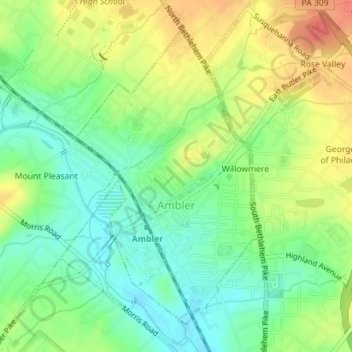
Name: Ambler topographic map, elevation, terrain.
Location: Ambler, Montgomery County, Pennsylvania, United States (40.14536 -75.23161 40.16810 -75.21307)
Average elevation: 76 m
Minimum elevation: 51 m
Maximum elevation: 107 m
Other topographic maps
Click on a map to view its topography, its elevation and its terrain.
Edge Hill
United States > Pennsylvania > Montgomery County > Cheltenham Township > Glenside
Average elevation: 94 m
Betzwood
United States > Pennsylvania > Montgomery County > West Norriton Township
Average elevation: 48 m
Penn Wynne
United States > Pennsylvania > Montgomery County > Lower Merion Township
Average elevation: 76 m
Bryn Mawr
United States > Pennsylvania > Montgomery County > Lower Merion Township
Average elevation: 109 m
Penllyn
United States > Pennsylvania > Montgomery County > Lower Gwynedd Township
Average elevation: 85 m
Lafayette Hill
United States > Pennsylvania > Montgomery County > Whitemarsh Township
Average elevation: 59 m
Willow Grove
United States > Pennsylvania > Montgomery County > Upper Moreland Township
Average elevation: 91 m
New Hanover
United States > Pennsylvania > Montgomery County > New Hanover Township
Average elevation: 91 m
Gwynedd
United States > Pennsylvania > Montgomery County > Lower Gwynedd Township
Average elevation: 111 m
Belmont Terrace
United States > Pennsylvania > Montgomery County > Upper Merion Township > King of Prussia
Average elevation: 45 m
Eagleville
United States > Pennsylvania > Montgomery County > Lower Providence Township
Average elevation: 102 m
Wynmere Downs
United States > Pennsylvania > Montgomery County > Horsham Township
Average elevation: 98 m
Unami Creek
United States > Pennsylvania > Montgomery County > Marlborough Township
Average elevation: 125 m
Elkins Park Gardens
United States > Pennsylvania > Montgomery County > Cheltenham Township > Cheltenham
Average elevation: 70 m
Bala Cynwyd
United States > Pennsylvania > Montgomery County > Lower Merion Township
Average elevation: 75 m
Palm
United States > Pennsylvania > Montgomery County > Upper Hanover Township
Average elevation: 131 m
Village of Mingo
United States > Pennsylvania > Montgomery County > Upper Providence Township
Average elevation: 70 m
Bergey
United States > Pennsylvania > Montgomery County > Upper Salford Township
Average elevation: 93 m
Haverford
United States > Pennsylvania > Montgomery County > Lower Merion Township > Ardmore
Average elevation: 103 m
Mainland
United States > Pennsylvania > Montgomery County > Lower Salford Township
Average elevation: 79 m
Horsham Township
United States > Pennsylvania > Montgomery County
The township's early social and economic life revolved around this Meeting House. In a similar way, Prospectville, originally known as Cashtown, was established at the junction of two roads, Limekiln Pike and Horsham Road. This portion of Limekiln Pike was an extension of the original segment established in…
Average elevation: 93 m
Montgomeryville
United States > Pennsylvania > Montgomery County > Montgomery Township > Montgomeryville
Average elevation: 119 m
Fort Washington
United States > Pennsylvania > Montgomery County > Upper Dublin Township > Fort Washington
Average elevation: 76 m
Mount Joy
United States > Pennsylvania > Montgomery County > Upper Merion Township
Average elevation: 69 m
Oreland
United States > Pennsylvania > Montgomery County > Upper Dublin Township
Average elevation: 80 m
Norristown
United States > Pennsylvania > Montgomery County
In the Köppen climate classification, the borough has a humid subtropical climate (Cfa) according to recent temperature numbers. The Trewartha climate classification now has the climate as Do (oceanic because only seven months are above 50 °F.) The hardiness zone is 7a or 7b depending upon elevation.
Average elevation: 50 m
Pennsburg
United States > Pennsylvania > Montgomery County
Pennsburg is located at 40°23′44″N 75°29′50″W / 40.39556°N 75.49722°W / 40.39556; -75.49722 (40.395595, −75.497361). According to the United States Census Bureau, the borough has a total area of 0.8 square miles (2.1 km2), all of it land. Pennsburg is located 40 mi (64 km) northwest of…
Average elevation: 107 m
Albidale
United States > Pennsylvania > Montgomery County > Lower Moreland Township > Albidale
Average elevation: 77 m
Wyncote
United States > Pennsylvania > Montgomery County > Cheltenham Township > Wyncote
Average elevation: 87 m
Ashbourne
United States > Pennsylvania > Montgomery County > Cheltenham Township
Average elevation: 70 m
King of Prussia
United States > Pennsylvania > Montgomery County > Upper Merion Township
Average elevation: 59 m
Lafayette Park
United States > Pennsylvania > Montgomery County > King of Prussia > Lafayette Park
Average elevation: 54 m
Perkiomenville
United States > Pennsylvania > Montgomery County > Marlborough Township
Average elevation: 97 m