Geolocate

Antigua topographic map

Interactive map

Click on the map to display elevation.

About this map

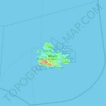
Name: Antigua topographic map, elevation, terrain.

Location: Antigua, Antigua and Barbuda (16.77399 -62.14719 17.43300 -61.44764)

Average elevation: 2 m

Minimum elevation: -1 m

Maximum elevation: 363 m

Other topographic maps

Click on a map to view its topography, its elevation and its terrain.

Jolly Harbour

Antigua and Barbuda > Antigua

Average elevation: 25 m

Liberta

Antigua and Barbuda > Antigua

Average elevation: 92 m

Bolans

Antigua and Barbuda > Antigua

Average elevation: 47 m

Herberts

Antigua and Barbuda > Antigua

Average elevation: 37 m

All Saints

Antigua and Barbuda > Antigua

Average elevation: 65 m

Boggy Peak

Antigua and Barbuda > Antigua > Bolans

Average elevation: 166 m

St. John's

Antigua and Barbuda > Antigua

Average elevation: 23 m

Coolidge

Antigua and Barbuda > Coolidge

Average elevation: 22 m

St. John's

Antigua and Barbuda > Antigua

Average elevation: 23 m