
Make a donation
Gear up for your next adventure:
As an Amazon Associate, this site earns from qualifying purchases at no extra cost to you.
Apeldoorn topographic map
Click on the map to display elevation.
Make a donation
Gear up for your next adventure:
As an Amazon Associate, this site earns from qualifying purchases at no extra cost to you.
Apeldoorn
In 1689 William III became King of England, Scotland and Ireland and this elevation of his position and power brought an enlargement of Het Loo in its wake. Between 1691 and 1694 the colonnades which linked the corps de logis to the wings on either side were replaced by four pavilions. These pavilions contained the new apartments of William III and Mary II, a new Dining Room, a Long Gallery and a Chapel. Queen Mary did not return to the Netherlands after 1689 and never saw the enlargement.
Make a donation
Gear up for your next adventure:
As an Amazon Associate, this site earns from qualifying purchases at no extra cost to you.
About this map
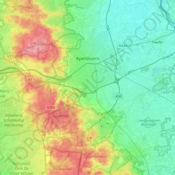
Name: Apeldoorn topographic map, elevation, terrain.
Location: Apeldoorn, Gelderland, Netherlands (52.07334 5.72639 52.28567 6.07848)
Average elevation: 36 m
Minimum elevation: 1 m
Maximum elevation: 110 m
Make a donation
Gear up for your next adventure:
As an Amazon Associate, this site earns from qualifying purchases at no extra cost to you.
Other topographic maps
Click on a map to view its topography, its elevation and its terrain.
Make a donation
Gear up for your next adventure:
As an Amazon Associate, this site earns from qualifying purchases at no extra cost to you.
Make a donation
Gear up for your next adventure:
As an Amazon Associate, this site earns from qualifying purchases at no extra cost to you.
Make a donation
Gear up for your next adventure:
As an Amazon Associate, this site earns from qualifying purchases at no extra cost to you.
Make a donation
Gear up for your next adventure:
As an Amazon Associate, this site earns from qualifying purchases at no extra cost to you.