
Make a donation
Gear up for your next adventure:
As an Amazon Associate, this site earns from qualifying purchases at no extra cost to you.
Oecussi-Ambeno topographic map
Click on the map to display elevation.
Make a donation
Gear up for your next adventure:
As an Amazon Associate, this site earns from qualifying purchases at no extra cost to you.
Oecussi-Ambeno
The temperature in Oecusse depends on elevation. In the coastal lowlands, it is about 31–33 °C (88–91 °F) in daytime (20–25 °C (68–77 °F) at night). With each 1,000 m (3,300 ft) of elevation, it decreases about 4–5 °C (39–41 °F). The annual precipitation rate is 1,000–2,500 mm (39–98 in). As in many parts of Timor, some areas become isolated in the rainy season because of flooding.
Make a donation
Gear up for your next adventure:
As an Amazon Associate, this site earns from qualifying purchases at no extra cost to you.
About this map
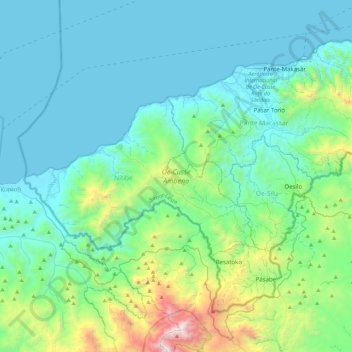
Name: Oecussi-Ambeno topographic map, elevation, terrain.
Location: Oecussi-Ambeno, East Timor (-9.50417 124.04157 -9.16688 124.48292)
Average elevation: 367 m
Minimum elevation: 0 m
Maximum elevation: 2,234 m
Make a donation
Gear up for your next adventure:
As an Amazon Associate, this site earns from qualifying purchases at no extra cost to you.
Other topographic maps
Click on a map to view its topography, its elevation and its terrain.
Make a donation
Gear up for your next adventure:
As an Amazon Associate, this site earns from qualifying purchases at no extra cost to you.
Make a donation
Gear up for your next adventure:
As an Amazon Associate, this site earns from qualifying purchases at no extra cost to you.
Same
The city is located in the interior of the island, 49 kilometres (30 mi) south of the provincial capital of Dili, at an altitude of 384 metres (1,260 ft), south of the mountain Cabalaki (Foho Kabulaki). The centre is located in the Suco Letefoho in which are situated the districts Ria-Lau (Rialau) Manico 1, 2…
Average elevation: 531 m
Make a donation
Gear up for your next adventure:
As an Amazon Associate, this site earns from qualifying purchases at no extra cost to you.
Make a donation
Gear up for your next adventure:
As an Amazon Associate, this site earns from qualifying purchases at no extra cost to you.
Gleno
Gleno has a tropical savanna climate (Köppen Aw), bordering on a tropical monsoon climate (Am), moderated by elevation. The dry season peaks in August and September, whilst the wet season extends from November to May with a peak from December to February. Gleno is substantially cooler and much wetter than…
Average elevation: 839 m
Make a donation
Gear up for your next adventure:
As an Amazon Associate, this site earns from qualifying purchases at no extra cost to you.
Dili
The main city lies within an area of flat lowlands of less than 100m altitude and a slope under 15 degrees. This distance between the sea and the mountains reaches a maximum width of only 4 kilometres (2.5 mi), and the surrounding mountains slope near the city at angles of 20 degrees or higher. The old quarter…
Average elevation: 337 m
Make a donation
Gear up for your next adventure:
As an Amazon Associate, this site earns from qualifying purchases at no extra cost to you.
Make a donation
Gear up for your next adventure:
As an Amazon Associate, this site earns from qualifying purchases at no extra cost to you.
Jaco
East Timor > Lautém > Tutuala
The island is low-lying, with an area of 11 km2 (4.2 sq mi) and a maximum elevation of about 100 m (330 ft). It is covered mainly by tropical dry forest, fringed by strand vegetation and white sandy beaches. There are some low cliffs on the southern coast.
Average elevation: 23 m
Make a donation
Gear up for your next adventure:
As an Amazon Associate, this site earns from qualifying purchases at no extra cost to you.
Jaco
East Timor > Lautém > Tutuala
The island is low-lying, with an area of 11 km2 (4.2 sq mi) and a maximum elevation of about 100 m (330 ft). It is covered mainly by tropical dry forest, fringed by strand vegetation and sandy beaches. There are some low cliffs on the southern coast.
Average elevation: 17 m