
Întorsura Buzăului topographic map
Interactive map
Click on the map to display elevation.
About this map
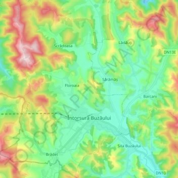
Name: Întorsura Buzăului topographic map, elevation, terrain.
Location: Întorsura Buzăului, Covasna, Romania (45.63741 25.95131 45.74807 26.06707)
Average elevation: 790 m
Minimum elevation: 652 m
Maximum elevation: 1,060 m
Întorsura Buzăului is located at 750 m (2,460 ft) altitude, in a depression, surrounded by the Întorsurii [ro], Ciucaș, and Siriu [ro] mountains. Due to its location, the town registers the lowest temperatures in Romania every year.
Other topographic maps
Click on a map to view its topography, its elevation and its terrain.
Sfântu Gheorghe
Romania > Covasna > Sfântu Gheorghe
Sfântu Gheorghe, Covasna, Romania
Average elevation: 551 m