
Brookland topographic map
Interactive map
Click on the map to display elevation.
About this map
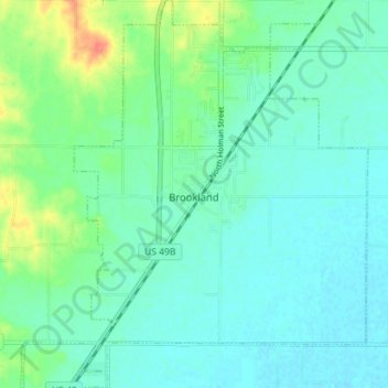
Name: Brookland topographic map, elevation, terrain.
Location: Brookland, Craighead County, Arkansas, 72417, United States (35.87188 -90.60412 35.92918 -90.55025)
Average elevation: 83 m
Minimum elevation: 72 m
Maximum elevation: 116 m
Other topographic maps
Click on a map to view its topography, its elevation and its terrain.
Jonesboro
United States > Arkansas > Craighead County > Jonesboro
Jonesboro, Craighead County, Arkansas, United States
Average elevation: 90 m
Bono
United States > Arkansas > Craighead County
Bono, Craighead County, Arkansas, United States
Average elevation: 86 m
Bay
United States > Arkansas > Craighead County
Bay, Craighead County, Arkansas, 72411, United States
Average elevation: 69 m
Lake City
United States > Arkansas > Craighead County
Lake City, Craighead County, Arkansas, 72437, United States
Average elevation: 69 m
Egypt
United States > Arkansas > Craighead County
Egypt, Craighead County, Arkansas, 72427, United States
Average elevation: 76 m
Jonesboro
United States > Arkansas > Craighead County > Jonesboro
Jonesboro, Craighead County, Arkansas, 72401, United States
Average elevation: 87 m