
4e Arrondissement topographic map
Interactive map
Click on the map to display elevation.
About this map
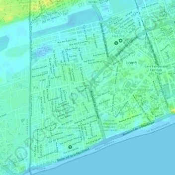
Name: 4e Arrondissement topographic map, elevation, terrain.
Location: 4e Arrondissement, Lomé, Togo (6.11236 1.19935 6.14044 1.22209)
Average elevation: 6 m
Minimum elevation: -3 m
Maximum elevation: 22 m
Other topographic maps
Click on a map to view its topography, its elevation and its terrain.
Baie d'Atikoumé
Baie d'Atikoumé, Akossombo, Lomé, 5e Arrondissement, Togo
Average elevation: 21 m