
Lago Winnipeg topographic map
Interactive map
Click on the map to display elevation.
About this map
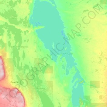
Name: Lago Winnipeg topographic map, elevation, terrain.
Location: Lago Winnipeg, Manitoba, Canadá (50.29800 -99.26855 53.87945 -96.26135)
Average elevation: 272 m
Minimum elevation: 212 m
Maximum elevation: 741 m
Other topographic maps
Click on a map to view its topography, its elevation and its terrain.
Fort Rouge–East Fort Garry
Fort Rouge–East Fort Garry, Winnipeg, Manitoba, Canadá
Average elevation: 234 m