Geolocate

Toronto topographic map

Click on the map to display elevation.

Toronto

Despite its deep ravines, Toronto is not remarkably hilly, but its elevation does increase steadily away from the lake. Elevation differences range from 76.5 metres (251 ft) above sea level at the Lake Ontario shore to 209 m (686 ft) ASL near the York University grounds in the city's north end at the intersection of Keele Street and Steeles Avenue. There are occasional hilly areas; in particular, midtown Toronto has a number of sharply sloping hills. Lake Ontario remains occasionally visible from the peaks of these ridges as far north as Eglinton Avenue, 7 to 8 kilometres (4.3 to 5.0 mi) inland.

Wikipedia (CC-BY-SA 3.0)

About this map

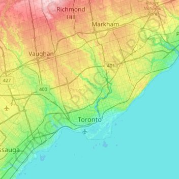
Name: Toronto topographic map, elevation, terrain.

Location: Toronto, Golden Horseshoe, Ontario, Canada (43.57961 -79.63928 43.85544 -79.11322)

Average elevation: 139 m

Minimum elevation: 70 m

Maximum elevation: 330 m

Other topographic maps

Click on a map to view its topography, its elevation and its terrain.

Toronto

Canada > Ontario > Toronto

Despite its deep ravines, Toronto is not remarkably hilly, but its elevation does increase steadily away from the lake. Elevation differences range from 76.5 metres (251 ft) above sea level at the Lake Ontario shore to 209 m (686 ft) ASL near the York University grounds in the city's north end at the…

Average elevation: 113 m

London

Canada > Ontario > London > London

London has a humid continental climate (Köppen Dfb), though due to its downwind location relative to Lake Huron and elevation changes across the city, it is virtually on the Dfa/Dfb (hot summer) boundary favouring the former climate zone to the southwest of the confluence of the South and North Thames Rivers,…

Average elevation: 268 m

Guelph

Canada > Ontario > Guelph

This region of Ontario has cold winters and warm, humid summers, falling into the Köppen climate classification Dfb zone, with moderately high rainfall and snowfall. It is generally a couple of degrees cooler than lower elevation regions on the Great Lakes shorelines, especially so in winter, the exception…

Average elevation: 344 m

Haliburton

Canada > Ontario

Average elevation: 358 m

Windsor

Canada > Ontario > Windsor

Average elevation: 185 m

Calabogie

Canada > Ontario > Renfrew County > Greater Madawaska

Average elevation: 163 m

Peterborough

Canada > Ontario > Peterborough

Peterborough's topography is largely defined by land formations created by the receding Wisconsian glaciers 10,000–15,000 years ago. The South End and Downtown portions of the City sit on what was the bottom of the glacial Lake Peterborough—part of a glacial spillway created when glacial meltwaters from…

Average elevation: 235 m

Niagara Escarpment

Canada > Ontario > Hamilton

Average elevation: 162 m

Hamilton

Canada > Ontario > Hamilton

Average elevation: 181 m

Stratford

Canada > Ontario > Stratford

Average elevation: 356 m

Port Dover

Canada > Ontario > Norfolk County

Average elevation: 187 m

Hamilton Mountain

Canada > Ontario > Hamilton

Average elevation: 164 m

Elmira

Canada > Ontario > Region of Waterloo > Woolwich

Average elevation: 362 m

Parry Sound

Canada > Ontario

Average elevation: 235 m

St. Thomas

Canada > Ontario > St. Thomas

Average elevation: 231 m

Achigan Lake

Canada > Ontario > Unorganized North Algoma

Average elevation: 377 m

Niagara Escarpment

Canada > Ontario

Average elevation: 299 m

Kingston

Canada > Ontario > Kingston

Average elevation: 94 m

Prince Edward

Canada > Ontario

Average elevation: 118 m

Mount Albert

Canada > Ontario > York Region

Average elevation: 261 m

Griffith

Canada > Ontario > Renfrew County > Greater Madawaska

Average elevation: 292 m

Rockwood

Canada > Ontario > Wellington County > Guelph/Eramosa

Average elevation: 364 m

Val Caron

Canada > Ontario > Sudbury District > Greater Sudbury

Average elevation: 295 m

Chapleau

Canada > Ontario > Sudbury District > Chapleau Township

Average elevation: 444 m

Harrow

Canada > Ontario > Essex County

Average elevation: 189 m

Rangers Bay

Canada > Ontario > Sudbury District > French River

Average elevation: 198 m

Arkona

Canada > Ontario > Lambton County > Lambton Shores

Average elevation: 235 m

New Tecumseth

Canada > Ontario > Simcoe County

Average elevation: 269 m

Brule Lake

Canada > Ontario > Renfrew County > Greater Madawaska

Average elevation: 351 m

Arthur

Canada > Ontario > Wellington County > Wellington North

Average elevation: 460 m

Cambridge

Canada > Ontario > Cambridge

Average elevation: 295 m

Kenora

Canada > Ontario

Average elevation: 182 m

Kawartha Lakes

Canada > Ontario > Kawartha Lakes

Average elevation: 269 m

Perth

Canada > Ontario

Average elevation: 313 m

Lambton

Canada > Ontario

Average elevation: 188 m

Essex

Canada > Ontario

Average elevation: 193 m

Tobermory

Canada > Ontario > Northern Bruce Peninsula > Tobermory

The deep waters at the mouth of Georgian Bay are home to Fathom Five, Canada's first National Marine Conservation Area. The park preserves a rich cultural legacy that includes 22 shipwrecks and several historic lighthouses. Fathom Five's freshwater ecosystem contains some of the most pristine waters of the…

Average elevation: 182 m

Lac Seul

Canada > Ontario

Average elevation: 365 m

Hockley Valley

Canada > Ontario > Peel Region > Caledon

Average elevation: 281 m

Harlem Shoal

Canada > Ontario

Average elevation: 175 m

St. Johns

Canada > Ontario

Average elevation: 205 m

Verner

Canada > Ontario > Nipissing District

Average elevation: 228 m

Quetico Provincial Park

Canada > Ontario

Average elevation: 432 m

Ohsweken

Canada > Ontario

Average elevation: 208 m

Sagamok

Canada > Ontario

Average elevation: 210 m

Combermere

Canada > Ontario > Renfrew County > Madawaska Valley

Average elevation: 318 m

Pinehurst Lake

Canada > Ontario

Average elevation: 295 m

Docker Lake

Canada > Ontario

Average elevation: 377 m

Oneida Nation of the Thames

Canada > Ontario

Average elevation: 224 m

Bigwin Island

Canada > Ontario

Average elevation: 328 m

Upper Pergeon Lake

Canada > Ontario

Average elevation: 215 m

York River

Canada > Ontario

Average elevation: 397 m

Kawartha Lakes (city)

Canada > Ontario

Average elevation: 274 m

Pelee Island

Canada > Ontario

Average elevation: 173 m

Conestoga Lake

Canada > Ontario > Wellington County > Mapleton

Average elevation: 412 m

Dufferin Grove Park

Canada > Ontario > Old Toronto

Average elevation: 109 m

Quinte West (city)

Canada > Ontario

Average elevation: 160 m

London

Canada > Ontario

London has a humid continental climate (Köppen Dfb), though due to its downwind location relative to Lake Huron and elevation changes across the city, it is virtually on the Dfa/Dfb (hot summer) boundary favouring the former climate zone to the southwest of the confluence of the South and North Thames Rivers,…

Average elevation: 269 m

Lambton

Canada > Ontario

Average elevation: 191 m

Algoma District

Canada > Ontario

Average elevation: 360 m

London (city)

Canada > Ontario

Average elevation: 239 m

French River

Canada > Ontario > Sudbury District

Average elevation: 208 m

Lindsay

Canada > Ontario > Kawartha Lakes

Average elevation: 268 m

Westport

Canada > Ontario > Leeds and Grenville Counties

Average elevation: 146 m

Bruce Peninsula

Canada > Ontario > Grey County > Georgian Bluffs

Average elevation: 240 m

Rattlesnake Point

Canada > Ontario > Milton

Average elevation: 244 m

Constance Bay

Canada > Ontario > Ottawa

Average elevation: 65 m

Frontenac Provincial Park

Canada > Ontario > South Frontenac

Frontenac Provincial Park is located near the town of Sydenham, north of the city of Kingston, Ontario, Canada. The Government of Ontario has classified Frontenac Provincial Park as a natural environment park. The park lies on the Frontenac Axis, a topographic extension of the Canadian Shield, which connects…

Average elevation: 151 m

Cameron Lake

Canada > Ontario > Kawartha Lakes > Fenelon Falls

Average elevation: 254 m

Mair Lake

Canada > Ontario > Frontenac County > North Frontenac

Average elevation: 274 m

Niagara Escarpment

Canada > Ontario > Burlington

Average elevation: 216 m

Balsam Lake

Canada > Ontario > Kawartha Lakes

Average elevation: 257 m

Muskoka River

Canada > Ontario > Muskoka District > Bracebridge

Average elevation: 246 m

Callander Bay

Canada > Ontario > Parry Sound District > Callander

Average elevation: 194 m

West Flamborough

Canada > Ontario > Hamilton

Average elevation: 227 m

Angus

Canada > Ontario > Simcoe County > Essa

Average elevation: 199 m

Lanark

Canada > Ontario > Lanark Highlands > Lanark

Average elevation: 153 m

Fonthill

Canada > Ontario > Niagara Region

Average elevation: 193 m

Cookstown

Canada > Ontario > Simcoe County > Innisfil > Cookstown

Average elevation: 242 m

Caledonia

Canada > Ontario > Haldimand County

Average elevation: 204 m

Monarch Park

Canada > Ontario > Old Toronto

Average elevation: 106 m

Pike Lake

Canada > Ontario > Sudbury District > Greater Sudbury

Average elevation: 387 m

Colchester

Canada > Ontario > Essex County > Town of Essex

Average elevation: 180 m

Gear up for your next adventure:

🍳Camping Stoves - Compact stoves for outdoor cooking
🔥Emergency Fire Starters - Reliable ignition tools for survival situations in damp conditions
🍱Food Containers - Reusable containers for outdoor meals
🔋Lithium AA Batteries - Long-lasting power that performs well in cold mountain weather
📱Phone Mounts for Hiking - Secure mounts to carry your phone on trails

As an Amazon Associate, this site earns from qualifying purchases at no extra cost to you.