Make a donation
Gear up for your next adventure:
As an Amazon Associate, this site earns from qualifying purchases at no extra cost to you.
Famy topographic map
Click on the map to display elevation.
Make a donation
Gear up for your next adventure:
As an Amazon Associate, this site earns from qualifying purchases at no extra cost to you.
About this map
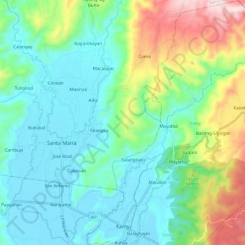
Name: Famy topographic map, elevation, terrain.
Location: Famy, Laguna, Calabarzon, 4021, Philippines (14.42762 121.43365 14.52892 121.51249)
Average elevation: 155 m
Minimum elevation: 1 m
Maximum elevation: 584 m
Make a donation
Gear up for your next adventure:
As an Amazon Associate, this site earns from qualifying purchases at no extra cost to you.
Other topographic maps
Click on a map to view its topography, its elevation and its terrain.
Make a donation
Gear up for your next adventure:
As an Amazon Associate, this site earns from qualifying purchases at no extra cost to you.
Mount San Cristobal
Philippines > Laguna > Rizal
Mount San Cristobal is a potentially active stratovolcano at the boundary of the provinces of Laguna and Quezon on the island of Luzon, Philippines. The mountain rises to an elevation of 1,470 m (4,820 ft) above mean sea level and is one of the volcanic features of Macolod Corridor.
Average elevation: 1,021 m
Make a donation
Gear up for your next adventure:
As an Amazon Associate, this site earns from qualifying purchases at no extra cost to you.
Make a donation
Gear up for your next adventure:
As an Amazon Associate, this site earns from qualifying purchases at no extra cost to you.
