
Quezon City topographic map
Interactive map
Click on the map to display elevation.
About this map
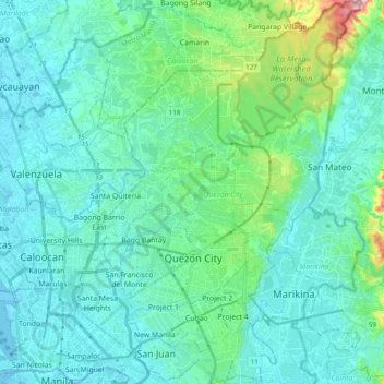
Name: Quezon City topographic map, elevation, terrain.
Location: Quezon City, Metro Manila, 1100, Philippines (14.58937 120.98967 14.77641 121.13383)
Average elevation: 39 m
Minimum elevation: -2 m
Maximum elevation: 252 m
In order to make Quezon's dream a reality and to mobilize funds for the land purchase, the People's Homesite Corporation (PHC) was created on October 14, 1938, as a subsidiary of NDC, with an initial capital of ₱2 million. Roces was the chairman of the Board of PHC, and they immediately acquired the vast Diliman Estate of the Tuason family at a cost of 5 centavos per square meter. PHC conducted topographical and subdivision surveys, and then subdivided the lots and sold them to the target buyers at an affordable price. Its target users and beneficiaries are obviously Manila's working class, who are suffering from the shortage of affordable and decent housing in the capital. The service of the Metropolitan Waterworks system was extended to site. The Bureau of Public Works, then under Secretary Vicente Fragante, constructed the streets and highways within the property. Quezon also tapped Architect Juan M. Arellano to draft a design of the city.
Other topographic maps
Click on a map to view its topography, its elevation and its terrain.
Sto. Tomas
Philippines > Batangas > Sto. Tomas > Santo Tomas
Sto. Tomas, Santo Tomas, Batangas, Calabarzon, 4234, Philippines
Average elevation: 154 m
Cagayan de Oro
Cagayan de Oro, Northern Mindanao, 9000, Philippines
Average elevation: 224 m
Manila
Manila, Fifth District, Manila, Metro Manila, Philippines
Average elevation: 6 m
Cotabato City
Philippines > Maguindanao > Cotabato City
Cotabato City, Maguindanao, Soccsksargen, 9600, Philippines
Average elevation: 97 m
Rajah Cabungso-an
Philippines > Davao Oriental > Lingig
Rajah Cabungso-an, Lingig, Davao Oriental, Davao Region, Philippines
Average elevation: 278 m
Calumpang River
Philippines > Batangas > Batangas City > Dalig
Calumpang River, Kumintang Ibaba, Poblacion, Dalig, Batangas City, Batangas, Calabarzon, 4200, Philippines
Average elevation: 30 m
San Luis River
Philippines > Batangas > Santa Teresita > Cutang Cawayan
San Luis River, Cutang Cawayan, Pacifico, Santa Teresita, Batangas, Calabarzon, 4206, Philippines
Average elevation: 178 m
Babo Sacan
Philippines > Pampanga > Porac
Babo Sacan, Porac, Pampanga, Central Luzon, 2008, Philippines
Average elevation: 81 m
Itogon
Itogon, Benguet, Cordillera Administrative Region, Philippines
Average elevation: 1,001 m
Alae River
Philippines > Misamis Oriental > Casinglot
Alae River, Casinglot, Misamis Oriental, Northern Mindanao, Philippines
Average elevation: 107 m
Mindoro
Philippines > Occidental Mindoro
Mindoro, Occidental Mindoro, Mimaropa, Philippines
Average elevation: 173 m
Rosario Heights XI
Rosario Heights XI, Cotabato City, Bangsamoro, 9600, Philippines
Average elevation: 5 m
Delfin Albano
Delfin Albano, Isabela, Cagayan Valley, 3326, Philippines
Average elevation: 33 m
Tumanding
Philippines > North Cotabato > Arakan
Tumanding, Arakan, North Cotabato, Soccsksargen, 9417, Philippines
Average elevation: 577 m
Caritan Norte
Philippines > Cagayan > Tuguegarao
Caritan Norte, Tuguegarao, Cagayan, Cagayan Valley, 3500, Philippines
Average elevation: 24 m
Santa Lucia
Philippines > Tarlac > Capas
Santa Lucia, Capas, Tarlac, Central Luzon, 2315, Philippines
Average elevation: 110 m
Talamban
Philippines > Negros Oriental > Jimalalud
Talamban, Jimalalud, Negros Oriental, Central Visayas, 6211, Philippines
Average elevation: 253 m
Panabo
Panabo, Davao del Norte, Davao Region, 8105, Philippines
Average elevation: 19 m
Matina Pangi
Matina Pangi, Davao City, Talomo District, Davao Region, 8000, Philippines
Average elevation: 53 m
Sta. Barbara
Sta. Barbara, Iloilo, Western Visayas, 5029, Philippines
Average elevation: 107 m
Sinikway
Philippines > Lapuz > Iloilo City
Sinikway, Iloilo City, Lapuz, Western Visayas, 5000, Philippines
Average elevation: 4 m
Barangay Mariana Park
Barangay Mariana Park, Mariana, New Manila, 4th District, Quezon City, Eastern Manila District, Metro Manila, 1112, Philippines
Average elevation: 23 m
Madrid
Madrid, Surigao del Sur, Caraga, 8316, Philippines
Average elevation: 22 m
Ballesteros
Ballesteros, Cagayan, Cagayan Valley, 3516, Philippines
Average elevation: 3 m
Cagayan De Oro
Philippines > Misamis Oriental > Cagayan De Oro
Cagayan De Oro, Misamis Oriental, Northern Mindanao, Philippines
Average elevation: 251 m
Basilan Island
Basilan Island, Basilan, Zamboanga Peninsula, Philippines
Average elevation: 72 m
Sierra Madre Mountain Range
Sierra Madre Mountain Range, Real, Calabarzon, 4335, Philippines
Average elevation: 64 m
Guimba
Guimba, Nueva Ecija, Central Luzon, 3115, Philippines
Average elevation: 33 m
Negros
Philippines > Negros Occidental > Himamaylan
Negros, Himamaylan, Negros Occidental, Western Visayas, 6108, Philippines
Average elevation: 210 m
Bulusukan Falls
Philippines > Marinduque > Buenavista
Bulusukan Falls, Buenavista, 2nd District, Marinduque, Mimaropa, 4904, Philippines
Average elevation: 293 m
Igbaras
Igbaras, Iloilo, Western Visayas, 5029, Philippines
Average elevation: 104 m
Sta. Elena
Sta. Elena, Camarines Norte, Bicol Region, 4603, Philippines
Average elevation: 5 m
Santa Lucia
Santa Lucia, Pasig, Eastern Manila District, Metro Manila, 1608, Philippines
Average elevation: 8 m
Talaga
Philippines > Batangas > Tanauan
Talaga, Tanauan, Batangas, Calabarzon, 4232, Philippines
Average elevation: 129 m