
Woody Island topographic map
Interactive map
Click on the map to display elevation.
About this map
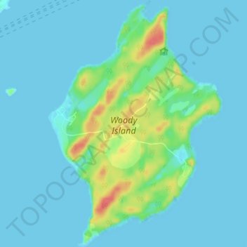
Name: Woody Island topographic map, elevation, terrain.
Location: Woody Island, Kodiak Island, Alaska, United States (57.76023 -152.36161 57.79822 -152.31132)
Average elevation: 9 m
Minimum elevation: -5 m
Maximum elevation: 53 m
Other topographic maps
Click on a map to view its topography, its elevation and its terrain.
Raspberry Island
United States > Alaska > Kodiak Island
Sitka spruce is one of the dominant trees on Raspberry Island. Spruce forests are interrupted by fields of salmonberry bushes, alders and wildflowers. Higher elevations have wild blueberry and cranberry bushes with more grasses. Wildlife of note on the island includes Sitka deer, red foxes and Kodiak bears, as…
Average elevation: 71 m
Trident Volcano
United States > Alaska > Kodiak Island
Trident Volcano is an eroded volcanic complex on the Alaska Peninsula in Katmai National Park, Alaska. Up to 23 domes comprise the complex stratovolcano, with the greatest elevation of 6,115 feet (1,864 m). The most recent major activity produced a 3,599-foot (1,097 m) dome in an amphitheater on the southwest…
Average elevation: 1,338 m
Mount Katmai
United States > Alaska > Kodiak Island
Mount Katmai (Russian: Катмай) is a large stratovolcano (composite volcano) on the Alaska Peninsula in southern Alaska, located within Katmai National Park and Preserve. It is about 6.3 miles (10 km) in diameter with a central lake-filled caldera about two by three miles (3.2 by 4.8 km) in size, formed…
Average elevation: 1,507 m