
Trident Volcano topographic map
Interactive map
Click on the map to display elevation.
About this map
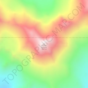
Name: Trident Volcano topographic map, elevation, terrain.
Location: Trident Volcano, Kodiak Island, Alaska, United States (58.23425 -155.10265 58.23435 -155.10255)
Average elevation: 1,338 m
Minimum elevation: 857 m
Maximum elevation: 1,845 m
Trident Volcano is an eroded volcanic complex on the Alaska Peninsula in Katmai National Park, Alaska. Up to 23 domes comprise the complex stratovolcano, with the greatest elevation of 6,115 feet (1,864 m). The most recent major activity produced a 3,599-foot (1,097 m) dome in an amphitheater on the southwest flank of the southwest peak. Volcano Novarupta formed on its slopes in the largest volcanic eruption of the 20th century.
Other topographic maps
Click on a map to view its topography, its elevation and its terrain.
Raspberry Island
United States > Alaska > Kodiak Island
Raspberry Island, Kodiak Island, Alaska, United States
Average elevation: 71 m
Woody Island
United States > Alaska > Kodiak Island
Woody Island, Kodiak Island, Alaska, United States
Average elevation: 9 m
Mount Katmai
United States > Alaska > Kodiak Island
Mount Katmai, Kodiak Island, Alaska, United States
Average elevation: 1,507 m
Kodiak
United States > Alaska > Kodiak Island
Kodiak, Kodiak Island, Alaska, United States
Average elevation: 62 m