
Raspberry Island topographic map
Interactive map
Click on the map to display elevation.
Raspberry Island
Sitka spruce is one of the dominant trees on Raspberry Island. Spruce forests are interrupted by fields of salmonberry bushes, alders and wildflowers. Higher elevations have wild blueberry and cranberry bushes with more grasses. Wildlife of note on the island includes Sitka deer, red foxes and Kodiak bears, as well as tufted puffins and bald eagles. Afognak and Raspberry islands are the only locations in Alaska with elk populations. The island's Roosevelt Elk developed from eight calves translocated from Washington state's Olympic Peninsula in 1928. The elk have adapted well to the island, with some mature bulls weighing nearly 1,300 pounds (590 kg). The muskrat is another species that was successfully introduced to the island. Whales commonly meander down Raspberry Strait but must turn around because it becomes too shallow for them to pass all the way through. Kayakers take advantage of this phenomenon to wait for them to pass by again on their way back out to deeper water. Bald eagles are abundant.
About this map
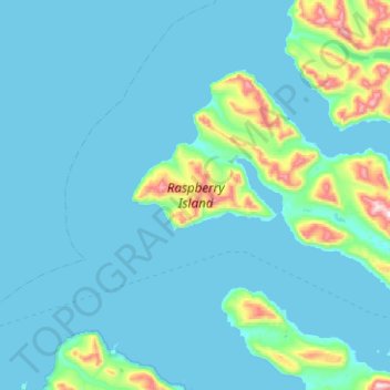
Name: Raspberry Island topographic map, elevation, terrain.
Location: Raspberry Island, Kodiak Island, Alaska, United States (57.97689 -153.41991 58.14824 -152.91793)
Average elevation: 71 m
Minimum elevation: -4 m
Maximum elevation: 725 m
Other topographic maps
Click on a map to view its topography, its elevation and its terrain.
Trident Volcano
United States > Alaska > Kodiak Island
Trident Volcano is an eroded volcanic complex on the Alaska Peninsula in Katmai National Park, Alaska. Up to 23 domes comprise the complex stratovolcano, with the greatest elevation of 6,115 feet (1,864 m). The most recent major activity produced a 3,599-foot (1,097 m) dome in an amphitheater on the southwest…
Average elevation: 1,338 m
Mount Katmai
United States > Alaska > Kodiak Island
Mount Katmai (Russian: Катмай) is a large stratovolcano (composite volcano) on the Alaska Peninsula in southern Alaska, located within Katmai National Park and Preserve. It is about 6.3 miles (10 km) in diameter with a central lake-filled caldera about two by three miles (3.2 by 4.8 km) in size, formed…
Average elevation: 1,507 m