
Braunwald topographic map
Interactive map
Click on the map to display elevation.
Braunwald
Braunwald is situated in the Glarus Alps on a terrace above the Linth valley, at an elevation of 1,256 meters (4,121 ft). It overlooks the villages of Linthal and Rüti in the valley below. It is overlooked by the mountains of Ortstock (2,717 m or 8,914 ft), Höch Turm (2,666 m or 8,747 ft), Eggstock (2,455 m or 8,054 ft) and Bös Fulen (2,802 m or 9,193 ft).
About this map
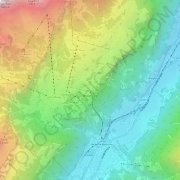
Name: Braunwald topographic map, elevation, terrain.
Location: Braunwald, Glarus Süd, Glarus, 8784, Switzerland (46.91926 8.97850 46.95926 9.01850)
Average elevation: 1,215 m
Minimum elevation: 588 m
Maximum elevation: 2,399 m
Other topographic maps
Click on a map to view its topography, its elevation and its terrain.
Schwanden
Switzerland > Glarus > Glarus Süd
Schwanden is situated at an elevation of 528 m (1,732 ft) at the point of confluence of the Linth and Sernf rivers. The village is located along the roads to Elm, Linthal and Schwändi, and includes the formerly independent (until 1876) hamlet of Thon. The villages of Nidfurn and Haslen lie to south in the…
Average elevation: 813 m
Mitlödi
Switzerland > Glarus > Glarus Süd > Mitlödi
Mitlödi is located in the valley of the Linth river, on a pre-historic rock slide, at an elevation of 504 m (1,654 ft). It consists of the village of Mitlödi itself, and the separate section of Ennetlinth on the right bank of the Linth. The village of Schwanden lies upstream and to the south, whilst the town…
Average elevation: 800 m