
Tödi topographic map
Interactive map
Click on the map to display elevation.
About this map
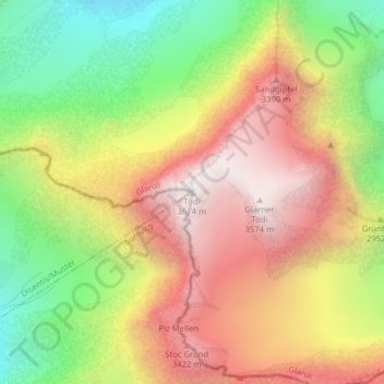
Name: Tödi topographic map, elevation, terrain.
Location: Tödi, Glarus Süd, Glarus, Switzerland (46.81110 8.91481 46.81120 8.91491)
Average elevation: 2,919 m
Minimum elevation: 2,219 m
Maximum elevation: 3,576 m
Other topographic maps
Click on a map to view its topography, its elevation and its terrain.
Braunwald
Switzerland > Glarus > Glarus Süd
Braunwald, Glarus Süd, Glarus, 8784, Switzerland
Average elevation: 1,215 m
Schwanden
Switzerland > Glarus > Glarus Süd
Schwanden, Glarus Süd, Glarus, 8762, Switzerland
Average elevation: 813 m
Schwander Grat
Switzerland > Glarus > Glarus Süd
Schwander Grat, Glarus Süd, Glarus, 8774, Switzerland
Average elevation: 2,289 m
Mitlödi
Switzerland > Glarus > Glarus Süd > Mitlödi
Mitlödi, Glarus Süd, Glarus, 8756, Switzerland
Average elevation: 800 m