
Make a donation
Gear up for your next adventure:
As an Amazon Associate, this site earns from qualifying purchases at no extra cost to you.
Mwala topographic map
Click on the map to display elevation.
Make a donation
Gear up for your next adventure:
As an Amazon Associate, this site earns from qualifying purchases at no extra cost to you.
About this map
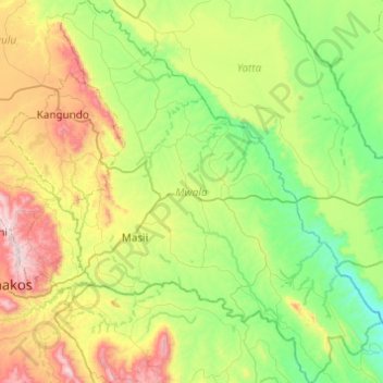
Name: Mwala topographic map, elevation, terrain.
Location: Mwala, Machakos County, Eastern, 90101, Kenya (-1.64668 37.34426 -1.15869 37.75419)
Average elevation: 1,307 m
Minimum elevation: 954 m
Maximum elevation: 2,119 m
Make a donation
Gear up for your next adventure:
As an Amazon Associate, this site earns from qualifying purchases at no extra cost to you.
Other topographic maps
Click on a map to view its topography, its elevation and its terrain.
Make a donation
Gear up for your next adventure:
As an Amazon Associate, this site earns from qualifying purchases at no extra cost to you.
Ol Donyo Sabuk
Kenya > Machakos County > Matungulu > Matungulu North ward
The Fourteen Falls area is protected and equipped with a picnic site. as it has historical and religious importance both to the residents and Asian immigrants. The Asians use the site for recreation and spiritual rites, disposing of cremated ash in the river in the belief that it will go all the way to India…
Average elevation: 1,866 m
Make a donation
Gear up for your next adventure:
As an Amazon Associate, this site earns from qualifying purchases at no extra cost to you.
Make a donation
Gear up for your next adventure:
As an Amazon Associate, this site earns from qualifying purchases at no extra cost to you.
Make a donation
Gear up for your next adventure:
As an Amazon Associate, this site earns from qualifying purchases at no extra cost to you.