
Village of Highland Falls topographic map
Interactive map
Click on the map to display elevation.
About this map
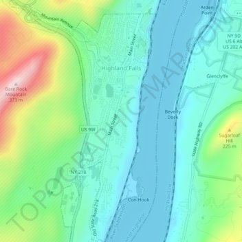
Name: Village of Highland Falls topographic map, elevation, terrain.
Average elevation: 93 m
Minimum elevation: 0 m
Maximum elevation: 371 m
Other topographic maps
Click on a map to view its topography, its elevation and its terrain.
Village of Cornwall-on-Hudson
United States > New York > Orange County > Town of Cornwall
Average elevation: 124 m
Town of Montgomery
United States > New York > Orange County
The town's topography is generally level and low, except along parts of its eastern and western boundaries, reflecting the passage of the Wallkill River through it from north to west. There are large swamps in the south portion of town, some of them draining into the Otter Kill. Further north, the land becomes…
Average elevation: 128 m
Village of Woodbury
United States > New York > Orange County > Town of Woodbury
Average elevation: 255 m
Beaver Dam Lake
United States > New York > Orange County > Town of Blooming Grove
Average elevation: 115 m
Cornwall Landing
United States > New York > Orange County > Village of Cornwall-on-Hudson
Average elevation: 74 m
City of Newburgh
United States > New York > Orange County
Adjacent to Newburgh, the land rises at first sharply to a bluff, where many historic structures are located, offering sweeping views of the Hudson Highlands to the south; Mount Beacon to the east and the Newburgh—Beacon Bridge to the north; then more gradually to a relatively level western half. There are…
Average elevation: 32 m
Nathaniel Wetlands Inventory - R5UBH - 0.09 acres
United States > New York > Orange County
Average elevation: 138 m
Montgomery
United States > New York > Orange County > Montgomery
These lands in the west are the lowest-lying in the village. Much of its topography rises gently from the river, with little relief save the Academy Hill area on the east edge of downtown where the village hall is located, and a 455-foot (139 m) hill at the junction of Purple Martin Road and Cardinal Drive…
Average elevation: 118 m
Village of Walden
United States > New York > Orange County > Town of Montgomery
The Wallkill passes through a small gorge between the two dams and loses approximately 60 feet (18 m) of elevation in the process. The surrounding topography in the village is, correspondingly, gentle rolling hills of this section of the Great Appalachian Valley between the higher rises of the Shawangunk…
Average elevation: 114 m
Village of Warwick
United States > New York > Orange County > Town of Warwick
Average elevation: 187 m