
Harstad topographic map
Click on the map to display elevation.
About this map
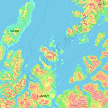
Name: Harstad topographic map, elevation, terrain.
Location: Harstad, Troms, Norway (68.55036 16.05231 69.31260 16.94581)
Average elevation: 144 m
Minimum elevation: -3 m
Maximum elevation: 1,274 m
Other topographic maps
Click on a map to view its topography, its elevation and its terrain.
Halti
Halti (Finnish: Halti, rarely Haltiatunturi, Northern Sami: Háldičohkka, Swedish: Haldefjäll) is a fell at the border between Norway and Finland. The peak (elevation 1,365 m (4,478 ft)) of the fell, called Ráisduottarháldi, is in Norway, on the border Nordreisa Municipality and Gáivuotna Municipality…
Average elevation: 1,192 m