
Stonington topographic map
Interactive map
Click on the map to display elevation.
About this map
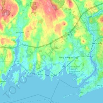
Name: Stonington topographic map, elevation, terrain.
Average elevation: 25 m
Minimum elevation: -1 m
Maximum elevation: 103 m
Other topographic maps
Click on a map to view its topography, its elevation and its terrain.
North Stonington
United States > Connecticut > Southeastern Connecticut Planning Region
North Stonington, Southeastern Connecticut Planning Region, Connecticut, 06338, United States
Average elevation: 73 m
Lebanon
United States > Connecticut > Southeastern Connecticut Planning Region
Lebanon, Southeastern Connecticut Planning Region, Connecticut, 06249, United States
Average elevation: 119 m
Mystic
United States > Connecticut > Southeastern Connecticut Planning Region > Stonington
Mystic, Stonington, Southeastern Connecticut Planning Region, Connecticut, 06388, United States
Average elevation: 17 m
Avery Hill
United States > Connecticut > Southeastern Connecticut Planning Region > Ledyard
Avery Hill, Ledyard, Southeastern Connecticut Planning Region, Connecticut, 06335, United States
Average elevation: 52 m
Waterford
United States > Connecticut > Southeastern Connecticut Planning Region
Waterford, Southeastern Connecticut Planning Region, Connecticut, United States
Average elevation: 30 m
Harkness Memorial State Park
United States > Connecticut > Southeastern Connecticut Planning Region > Waterford
Harkness Memorial State Park, Waterford, Southeastern Connecticut Planning Region, Connecticut, United States
Average elevation: 12 m
Seal Rocks
United States > Connecticut > Southeastern Connecticut Planning Region > Stonington
Seal Rocks, Stonington, Southeastern Connecticut Planning Region, Connecticut, 06388, United States
Average elevation: 37 m
Groton
United States > Connecticut > Southeastern Connecticut Planning Region
Groton, Southeastern Connecticut Planning Region, Connecticut, United States
Average elevation: 21 m
Norwich
United States > Connecticut > Southeastern Connecticut Planning Region
Norwich, Southeastern Connecticut Planning Region, Connecticut, United States
Average elevation: 63 m
New London
United States > Connecticut > Southeastern Connecticut Planning Region
New London, Southeastern Connecticut Planning Region, Connecticut, 06320, United States
Average elevation: 17 m
East Lyme
United States > Connecticut > Southeastern Connecticut Planning Region
East Lyme, Southeastern Connecticut Planning Region, Connecticut, 06376, United States, Blackboys
Average elevation: 38 m