
Waterford topographic map
Interactive map
Click on the map to display elevation.
About this map
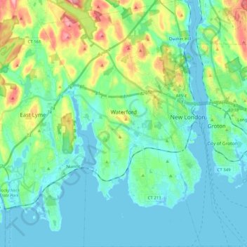
Name: Waterford topographic map, elevation, terrain.
Average elevation: 30 m
Minimum elevation: -3 m
Maximum elevation: 131 m
Other topographic maps
Click on a map to view its topography, its elevation and its terrain.
Chesterfield
United States > Connecticut > Southeastern Connecticut Planning Region > Montville
Average elevation: 77 m
Windham
United States > Connecticut > Southeastern Connecticut Planning Region
Average elevation: 103 m
Uncasville
United States > Connecticut > Southeastern Connecticut Planning Region > Montville
Average elevation: 40 m
Center Groton
United States > Connecticut > Southeastern Connecticut Planning Region > Groton
Average elevation: 49 m
Quaker Hill
United States > Connecticut > Southeastern Connecticut Planning Region > Waterford
Average elevation: 35 m
North Stonington
United States > Connecticut > Southeastern Connecticut Planning Region
Average elevation: 73 m
Lebanon
United States > Connecticut > Southeastern Connecticut Planning Region
Average elevation: 119 m
Mystic
United States > Connecticut > Southeastern Connecticut Planning Region > Stonington
Average elevation: 17 m
Avery Hill
United States > Connecticut > Southeastern Connecticut Planning Region > Ledyard
Average elevation: 52 m
Harkness Memorial State Park
United States > Connecticut > Southeastern Connecticut Planning Region > Waterford
Average elevation: 12 m
Seal Rocks
United States > Connecticut > Southeastern Connecticut Planning Region > Stonington
Average elevation: 37 m
Norwich
United States > Connecticut > Southeastern Connecticut Planning Region
Average elevation: 63 m
New London
United States > Connecticut > Southeastern Connecticut Planning Region
Average elevation: 17 m
Stonington
United States > Connecticut > Southeastern Connecticut Planning Region
Average elevation: 25 m