
North Stonington topographic map
Interactive map
Click on the map to display elevation.
About this map
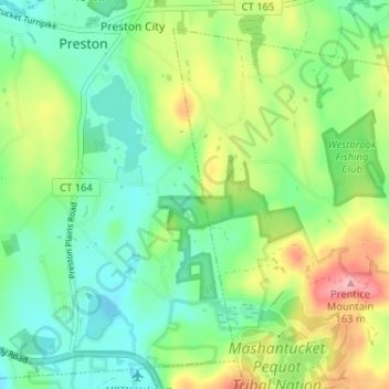
Name: North Stonington topographic map, elevation, terrain.
Average elevation: 73 m
Minimum elevation: 29 m
Maximum elevation: 157 m
Other topographic maps
Click on a map to view its topography, its elevation and its terrain.
Sprague
United States > Connecticut > Southeastern Connecticut Planning Region
Average elevation: 79 m
Montville
United States > Connecticut > Southeastern Connecticut Planning Region
Average elevation: 76 m
Oakdale
United States > Connecticut > Southeastern Connecticut Planning Region > Montville
Average elevation: 141 m
Quiambaug
United States > Connecticut > Southeastern Connecticut Planning Region > Mystic
Average elevation: 8 m
Four Corners
United States > Connecticut > Southeastern Connecticut Planning Region > Montville
Average elevation: 108 m
Manitock Spring
United States > Connecticut > Southeastern Connecticut Planning Region > Waterford
Average elevation: 26 m
Montville
United States > Connecticut > Southeastern Connecticut Planning Region
Average elevation: 80 m
Flanders
United States > Connecticut > Southeastern Connecticut Planning Region > East Lyme
Average elevation: 43 m
Chesterfield
United States > Connecticut > Southeastern Connecticut Planning Region > Montville
Average elevation: 77 m
Stonington
United States > Connecticut > Southeastern Connecticut Planning Region
Average elevation: 25 m
Ledyard
United States > Connecticut > Southeastern Connecticut Planning Region
Average elevation: 53 m
High Rock
United States > Connecticut > Southeastern Connecticut Planning Region > Waterford
Average elevation: 39 m
Flanders
United States > Connecticut > Southeastern Connecticut Planning Region > East Lyme
Average elevation: 43 m
Taftville
United States > Connecticut > Southeastern Connecticut Planning Region > Norwich
Average elevation: 47 m
East Lyme
United States > Connecticut > Southeastern Connecticut Planning Region
The topography of East Lyme consists of rolling hills and lush valleys rounded by glaciers during the last Ice Age. Hills rise to elevations of 250 to 350 feet (76 to 107 m) above sea level in the eastern and central areas of the town. The highest point in town is an unnamed hill with an elevation of 500 feet…
Average elevation: 41 m
Mystic
United States > Connecticut > Southeastern Connecticut Planning Region > Stonington > Mystic
Average elevation: 15 m
Uncasville
United States > Connecticut > Southeastern Connecticut Planning Region > Montville
Average elevation: 40 m
Chesterfield
United States > Connecticut > Southeastern Connecticut Planning Region > Montville
Average elevation: 77 m
Mystic
United States > Connecticut > Southeastern Connecticut Planning Region > Stonington > Mystic
Average elevation: 15 m
Windham
United States > Connecticut > Southeastern Connecticut Planning Region
Average elevation: 103 m
Center Groton
United States > Connecticut > Southeastern Connecticut Planning Region > Groton
Average elevation: 49 m
Waterford
United States > Connecticut > Southeastern Connecticut Planning Region
Average elevation: 30 m
New London
United States > Connecticut > Southeastern Connecticut Planning Region
Average elevation: 17 m
Quaker Hill
United States > Connecticut > Southeastern Connecticut Planning Region > Waterford
Average elevation: 35 m
Lebanon
United States > Connecticut > Southeastern Connecticut Planning Region
Average elevation: 119 m
East Lyme
United States > Connecticut > Southeastern Connecticut Planning Region
The topography of East Lyme consists of rolling hills and lush valleys rounded by glaciers during the last Ice Age. Hills rise to elevations of 250 to 350 feet (76 to 107 m) above sea level in the eastern and central areas of the town. The highest point in town is an unnamed hill with an elevation of 500 feet…
Average elevation: 41 m
New London
United States > Connecticut > Southeastern Connecticut Planning Region
Average elevation: 17 m
Colchester
United States > Connecticut > Southeastern Connecticut Planning Region
Average elevation: 134 m
Thames River
United States > Connecticut > Southeastern Connecticut Planning Region > Ledyard
Average elevation: 52 m
Norwich
United States > Connecticut > Southeastern Connecticut Planning Region
Average elevation: 63 m
Lebanon
United States > Connecticut > Southeastern Connecticut Planning Region
Average elevation: 119 m
Ledyard
United States > Connecticut > Southeastern Connecticut Planning Region
Average elevation: 53 m
Mystic
United States > Connecticut > Southeastern Connecticut Planning Region > Stonington
Average elevation: 17 m
Avery Hill
United States > Connecticut > Southeastern Connecticut Planning Region > Ledyard
Average elevation: 52 m
Waterford
United States > Connecticut > Southeastern Connecticut Planning Region
Average elevation: 30 m
Harkness Memorial State Park
United States > Connecticut > Southeastern Connecticut Planning Region > Waterford
Average elevation: 12 m
North Franklin
United States > Connecticut > Southeastern Connecticut Planning Region
Average elevation: 103 m
Seal Rocks
United States > Connecticut > Southeastern Connecticut Planning Region > Stonington
Average elevation: 37 m
Stonington
United States > Connecticut > Southeastern Connecticut Planning Region
Average elevation: 25 m
Gales Ferry
United States > Connecticut > Southeastern Connecticut Planning Region > Ledyard > Gales Ferry
Average elevation: 24 m
Norwich
United States > Connecticut > Southeastern Connecticut Planning Region
Average elevation: 63 m
New London
United States > Connecticut > Southeastern Connecticut Planning Region
Average elevation: 17 m
Stonington
United States > Connecticut > Southeastern Connecticut Planning Region
Average elevation: 25 m
Noank
United States > Connecticut > Southeastern Connecticut Planning Region > Groton > Noank
Average elevation: 15 m