Geolocate

Bara topographic map

Click on the map to display elevation.

About this map

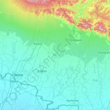
Name: Bara topographic map, elevation, terrain.

Location: Bara, Madhesh Province, Nepal (26.84918 84.86614 27.36565 85.27080)

Average elevation: 183 m

Minimum elevation: 69 m

Maximum elevation: 888 m

Other topographic maps

Click on a map to view its topography, its elevation and its terrain.

Simara

Nepal > Madhesh Province > Bara

Average elevation: 134 m

Chandranigahapur

Nepal > Madhesh Province > Rautahat

Average elevation: 133 m

Dhalkebar

Nepal > Madhesh Province > Dhanusha

Average elevation: 176 m

Jaleshwar

Nepal > Madhesh Province > Mahottari

Average elevation: 65 m

Kanchanpur

Nepal > Madhesh Province > Bara

Average elevation: 84 m

Ghurmi

Nepal > Madhesh Province > Siraha > Mirchaiya

Average elevation: 130 m

Harkapur

Nepal > Madhesh Province > Mahottari

Average elevation: 97 m

Banara

Nepal > Madhesh Province > Mahottari

Average elevation: 118 m

Birgunj

Nepal > Madhesh Province > Parsa

Birgunj is located in the Terai plain which is the northern part of the Indo-Gangetic plain. Birgunj metropolitan city has an elongated shape. The variation in altitude is in the range of 78 m to 95 m when moving from south to north of Birgunj. Although the range of altitude variation is small, but there is a…

Average elevation: 88 m

Gear up for your next adventure:

🥫Expedition Meals - Lightweight, high-calorie nutrition for long-distance hikers
🧊Personal Water Filters - Drink safely from mountain streams marked on your map
🚶Walking Pedometers - Simple distance tracking for casual trail walkers
🧢Hiking Hats - Sun and weather protection for outdoor walks
🧭GPS Trackers - Tracking devices for safety and navigation

As an Amazon Associate, this site earns from qualifying purchases at no extra cost to you.