
Harborough Magna CP topographic map
Interactive map
Click on the map to display elevation.
About this map
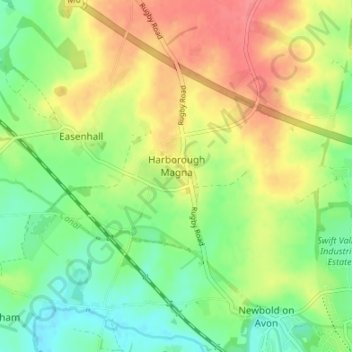
Name: Harborough Magna CP topographic map, elevation, terrain.
Average elevation: 106 m
Minimum elevation: 76 m
Maximum elevation: 142 m
Other topographic maps
Click on a map to view its topography, its elevation and its terrain.
Binley Woods CP
United Kingdom > England > Warwickshire > Rugby
Binley Woods CP, Rugby, Warwickshire, England, United Kingdom
Average elevation: 86 m
Ryton Pools Country Park
United Kingdom > England > Warwickshire > Rugby
Ryton Pools Country Park, Ryton on Dunsmore CP, Rugby, Warwickshire, England, CV8 3BG, United Kingdom
Average elevation: 82 m
Withybrook CP
United Kingdom > England > Warwickshire > Rugby
Withybrook CP, Rugby, Warwickshire, England, United Kingdom
Average elevation: 115 m
Newbold on Avon
United Kingdom > England > Warwickshire > Rugby
Newbold on Avon, Rugby, Warwickshire, England, CV21 1HQ, United Kingdom
Average elevation: 98 m
Churchover CP
United Kingdom > England > Warwickshire > Rugby
Churchover CP, Rugby, Warwickshire, England, United Kingdom
Average elevation: 115 m
Ryton Wood
United Kingdom > England > Warwickshire > Rugby > Ryton-on-Dunsmore
Ryton Wood, Ryton on Dunsmore CP, Ryton-on-Dunsmore, Rugby, Warwickshire, England, United Kingdom
Average elevation: 89 m
Monks Kirby CP
United Kingdom > England > Warwickshire > Rugby
Monks Kirby CP, Rugby, Warwickshire, England, United Kingdom
Average elevation: 117 m
Draycote Water
United Kingdom > England > Warwickshire > Rugby > Draycote
Draycote Water, Draycote, Rugby, Warwickshire, England, United Kingdom
Average elevation: 92 m
Thurlaston CP
United Kingdom > England > Warwickshire > Rugby
Thurlaston CP, Rugby, Warwickshire, England, United Kingdom
Average elevation: 98 m
Church Lawford CP
United Kingdom > England > Warwickshire > Rugby
Church Lawford CP, Rugby, Warwickshire, England, United Kingdom
Average elevation: 98 m
Wibtoft CP
United Kingdom > England > Warwickshire > Rugby > Wibtoft CP
Wibtoft CP, Rugby, Warwickshire, England, LE17 5BB, United Kingdom
Average elevation: 124 m
Frankton CP
United Kingdom > England > Warwickshire > Rugby > Frankton CP
Frankton CP, Rugby, Warwickshire, England, United Kingdom
Average elevation: 95 m
Dunchurch
United Kingdom > England > Warwickshire > Rugby
Dunchurch, Rugby, Warwickshire, England, United Kingdom
Average elevation: 102 m
Wolvey CP
United Kingdom > England > Warwickshire > Rugby
Wolvey CP, Rugby, Warwickshire, England, United Kingdom
Average elevation: 113 m
Barnacle
United Kingdom > England > Warwickshire > Rugby > Barnacle
Barnacle, Rugby, Warwickshire, West Midlands, England, CV7 9LE, United Kingdom
Average elevation: 102 m
Bramcote
United Kingdom > England > Warwickshire > Rugby
Bramcote, Rugby, Warwickshire, England, CV11 6QX, United Kingdom
Average elevation: 105 m
Newton
United Kingdom > England > Warwickshire > Rugby
Newton, Rugby, Warwickshire, England, CV23 0EE, United Kingdom
Average elevation: 114 m
Draycote
United Kingdom > England > Warwickshire > Rugby
Draycote, Rugby, Warwickshire, England, CV23 9RB, United Kingdom
Average elevation: 94 m
Bilton
United Kingdom > England > Warwickshire > Rugby
Bilton, Rugby, Warwickshire, England, CV22 7NL, United Kingdom
Average elevation: 111 m
Clifton upon Dunsmore CP
United Kingdom > England > Warwickshire > Rugby
Clifton upon Dunsmore CP, Rugby, Warwickshire, England, United Kingdom
Average elevation: 108 m
Long Lawford
United Kingdom > England > Warwickshire > Rugby
Long Lawford, Rugby, Warwickshire, England, CV23 9DA, United Kingdom
Average elevation: 95 m
Wolston CP
United Kingdom > England > Warwickshire > Rugby > Wolston CP
Wolston CP, Rugby, Warwickshire, England, United Kingdom
Average elevation: 89 m
Ryton-on-Dunsmore
United Kingdom > England > Warwickshire > Rugby
Ryton-on-Dunsmore, Rugby, Warwickshire, England, CV8 3EW, United Kingdom
Average elevation: 80 m