
Gloucester and Sharpness Canal topographic map
Interactive map
Click on the map to display elevation.
About this map
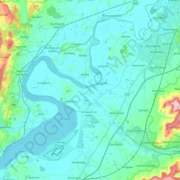
Name: Gloucester and Sharpness Canal topographic map, elevation, terrain.
Average elevation: 34 m
Minimum elevation: -2 m
Maximum elevation: 254 m
Gloucestershire trails, hiking, mountain biking, running and outdoor activities
Other topographic maps
Click on a map to view its topography, its elevation and its terrain.
Miserden Estate
United Kingdom > England > Gloucestershire > Stroud > Miserden
Average elevation: 218 m
Little Haresfield
United Kingdom > England > Gloucestershire > Stroud > Standish
Average elevation: 43 m
River Frome
United Kingdom > England > Gloucestershire > Stroud > Chalford > Chalford Hill
Average elevation: 163 m
Jubilee Playing Field & Athletics Track
United Kingdom > England > Gloucestershire > Stroud > Cam > Draycott
Average elevation: 45 m
Far Oakridge
United Kingdom > England > Gloucestershire > Stroud > Oakridge Lynch
Average elevation: 180 m
Draycott
United Kingdom > England > Gloucestershire > Stroud > Gossington > Draycott
Average elevation: 43 m