
Sylhet Division topographic map
Interactive map
Click on the map to display elevation.
Sylhet Division
The region is considered one of the most picturesque and archaeologically rich regions in South Asia. It is home to three national parks; the Lawachara National Park, Khadim Nagar National Park and Satchari National Park, as well as numerous smaller parks and forests such as the Ratargul Swamp Forest, Rema-Kalenga Wildlife Sanctuary. Its burgeoning economy has contributed to the regional attractions of landscapes filled with fragrant orange and pineapple gardens as well as tea plantations. The region has a tropical monsoon climate (Köppen Am) bordering on a humid subtropical climate (Cwa) at higher elevations. The rainy season from April to October is hot and humid with very heavy showers and thunderstorms almost every day, whilst the short dry season from November to February is very warm and fairly clear. Nearly 80% of the annual average rainfall of 4,200 millimetres (170 in) occurs between May and September.
About this map
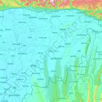
Name: Sylhet Division topographic map, elevation, terrain.
Location: Sylhet Division, Bangladesh (23.97438 90.91236 25.20735 92.49944)
Average elevation: 88 m
Minimum elevation: 0 m
Maximum elevation: 1,620 m
Other topographic maps
Click on a map to view its topography, its elevation and its terrain.
Dhaka
In 2013, suburban services to Narayanganj and Gazipur cities were upgraded using diesel electric multiple unit trains. The Dhaka Metro Rail feasibility study has been completed. A 20.1-kilometre (12.5 mi), $2.8-billion Phase 1 metro route is being negotiated by the Government with Japan International…
Average elevation: 7 m
Cox's Bazar
Bangladesh > Chattogram Division
Cox's Bazar lies on a coastal plain in the southeastern corner of Bangladesh. From above, the plain appears to bulge out into the Bay of Bengal. Along the shore is an extensive area of beach and dunes. Most of the city is built on a floodplain that is lower in elevation than the dunes, making it more…
Average elevation: 8 m
Chattogram
Bangladesh > Chattogram Division > Chattogram
Chittagong lies at 22°22′0″N 91°48′0″E / 22.36667°N 91.80000°E / 22.36667; 91.80000. It straddles the coastal foothills of the Chittagong Hill Tracts in southeastern Bangladesh. The Karnaphuli River runs along the southern banks of the city, including its central business district. The…
Average elevation: 6 m
Brahmaputra River
Bangladesh > Mymensingh Division > Jamalpur Sadar Upazila > Jamalpur
The course of the Brahmaputra River has changed drastically in the past two and a half centuries, moving its river course westwards for a distance of about 80 km (50 mi), leaving its old river course, appropriately named the old Brahmaputra river, behind. In the past, the floodplain of the old river course had…
Average elevation: 18 m
Mymensingh
Bangladesh > Mymensingh Division > Mymensingh Sadar Upazila
The city was constituted by the British East India Company on 1 May 1787. According to Ministry of Public Administration, Mymensingh is ranked 4th in district status. The population density of Mymensingh city is 44,458/km2 (115,150/sq mi), making it the second most densely populated city in Bangladesh.…
Average elevation: 14 m
Shahapur Play Ground
Bangladesh > Rangpur Division > Badarganj Upazila > Bodorganj
Average elevation: 34 m
Pond of Reshot Ali house
Bangladesh > Barishal Division > Borhanuddin Subdistrict
Average elevation: 5 m
Sylhet
Bangladesh > Sylhet Division > Sylhet Sadar Upazila
The name of Sylhet descended from Sanskrit word Srihatta (श्रीहट्ट / শ্রীহট্ট) which literally means elegant market. The name Sylhet is an anglicisation of Shilhot (শিলহট). Its origins seem to come from the Sanskrit according to the words of শিলা śilā…
Average elevation: 14 m
Tangail
Bangladesh > Dhaka Division > Tangail Sadar Upazila
The city of Tangail is in Dhaka Division, Central Bangladesh. The town lies in a low-lying floodplain near the Jamuna River, south of the high plateau of the Madhupur tract. The average elevation of Tangail is 14 meters (49 feet). Tangail experiences a Tropical savanna climate(Köppen: Aw ) with a hot, humid…
Average elevation: 11 m