
Make a donation
Gear up for your next adventure:
As an Amazon Associate, this site earns from qualifying purchases at no extra cost to you.
Tixkokob topographic map
Click on the map to display elevation.
Make a donation
Gear up for your next adventure:
As an Amazon Associate, this site earns from qualifying purchases at no extra cost to you.
Tixkokob
El territorio del municipio es completamente plano, como toda la Península de Yucatán, con una leve declinación hacia la costa, sin ninguna elevación de importancia.
Make a donation
Gear up for your next adventure:
As an Amazon Associate, this site earns from qualifying purchases at no extra cost to you.
About this map
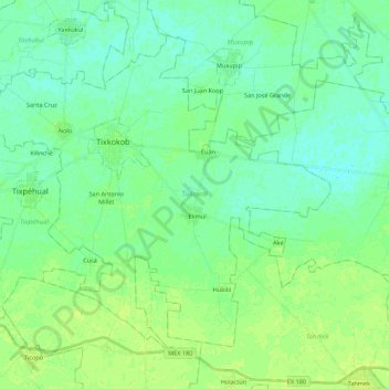
Name: Tixkokob topographic map, elevation, terrain.
Location: Tixkokob, Yucatán, 97470, México (20.89093 -89.49120 21.05913 -89.27213)
Average elevation: 11 m
Minimum elevation: 5 m
Maximum elevation: 17 m
Make a donation
Gear up for your next adventure:
As an Amazon Associate, this site earns from qualifying purchases at no extra cost to you.
Other topographic maps
Click on a map to view its topography, its elevation and its terrain.
Make a donation
Gear up for your next adventure:
As an Amazon Associate, this site earns from qualifying purchases at no extra cost to you.
Make a donation
Gear up for your next adventure:
As an Amazon Associate, this site earns from qualifying purchases at no extra cost to you.
Parque Paraiso Maya (GoRaids Altabrisa Norte)
México > Yucatán > Mérida > Mérida
Average elevation: 9 m