
Karkar Island topographic map
Interactive map
Click on the map to display elevation.
About this map
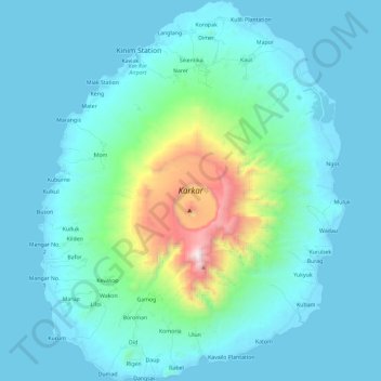
Name: Karkar Island topographic map, elevation, terrain.
Location: Karkar Island, Madang, Momase Region, Papua New Guinea (-4.75454 145.87903 -4.52071 146.06834)
Average elevation: 228 m
Minimum elevation: 0 m
Maximum elevation: 1,788 m
Other topographic maps
Click on a map to view its topography, its elevation and its terrain.
Moilsehu
Moilsehu, Madang, Momase Region, Papua New Guinea
Average elevation: 146 m