
Berin topographic map
Interactive map
Click on the map to display elevation.
About this map
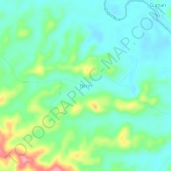
Name: Berin topographic map, elevation, terrain.
Location: Berin, Madang, Momase Region, Papua New Guinea (-5.26659 145.56668 -5.22659 145.60668)
Average elevation: 56 m
Minimum elevation: 22 m
Maximum elevation: 144 m
Other topographic maps
Click on a map to view its topography, its elevation and its terrain.
Karkar Island
Karkar Island, Madang, Momase Region, Papua New Guinea
Average elevation: 228 m
Moilsehu
Moilsehu, Madang, Momase Region, Papua New Guinea
Average elevation: 146 m