
Make a donation
Gear up for your next adventure:
As an Amazon Associate, this site earns from qualifying purchases at no extra cost to you.
Haripur topographic map
Click on the map to display elevation.
Make a donation
Gear up for your next adventure:
As an Amazon Associate, this site earns from qualifying purchases at no extra cost to you.
About this map
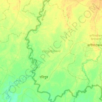
Name: Haripur topographic map, elevation, terrain.
Location: Haripur, Thakurgaon District, Rangpur Division, Bangladesh (25.77576 88.08551 26.00049 88.24208)
Average elevation: 42 m
Minimum elevation: 32 m
Maximum elevation: 52 m
Make a donation
Gear up for your next adventure:
As an Amazon Associate, this site earns from qualifying purchases at no extra cost to you.
Other topographic maps
Click on a map to view its topography, its elevation and its terrain.
Make a donation
Gear up for your next adventure:
As an Amazon Associate, this site earns from qualifying purchases at no extra cost to you.
Shapla Chattar
Bangladesh > Rangpur Division > Kurigram Sadar Upazila > Kurigram
Average elevation: 29 m
Make a donation
Gear up for your next adventure:
As an Amazon Associate, this site earns from qualifying purchases at no extra cost to you.
Shahapur Play Ground
Bangladesh > Rangpur Division > Badarganj Upazila > Bodorganj
Average elevation: 34 m
Make a donation
Gear up for your next adventure:
As an Amazon Associate, this site earns from qualifying purchases at no extra cost to you.
Make a donation
Gear up for your next adventure:
As an Amazon Associate, this site earns from qualifying purchases at no extra cost to you.
Kurigram
Bangladesh > Rangpur Division > Kurigram Sadar Upazila
The town of Kurigram located in the alluvial plain of Teesta-Brahmaputra basin at the bank of Dharla River . The avarage elevation of the town in 31 meter. Kurigram's humid subtropical climate (Köppen Cwa) is influenced by the monsoon and features mild winters and extremely rainy and wet summers. The region…
Average elevation: 27 m
Make a donation
Gear up for your next adventure:
As an Amazon Associate, this site earns from qualifying purchases at no extra cost to you.