
Towcester topographic map
Interactive map
Click on the map to display elevation.
About this map
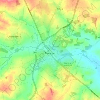
Name: Towcester topographic map, elevation, terrain.
Location: Towcester, West Northamptonshire, England, United Kingdom (52.10412 -1.03535 52.16501 -0.95726)
Average elevation: 111 m
Minimum elevation: 78 m
Maximum elevation: 158 m
St. Lawrence's C of E Church, stands in the middle of the town. It has a 12th-century Norman transitional ground plan and foundation, probably laid over a Saxon 10th century stone building. Its ecclesiastical heritage may well relate back to Roman times as St Lawrence was patron saint of the Roman legions. The building was reconstructed in the perpendicular style 1480–85 when the church tower was added. The tower contains 12 bells generally accepted by ringers across the country to be one of the finest sets in the Midlands. The bells were moved in 1994 from Todmorden in Yorkshire. Permission to quarry stone for this restoration from Whittlewood Forest was granted by Edward IV and later confirmed by Richard III on his way towards Leicestershire and his death at the Battle of Bosworth Field. The church contains a "Treacle" Bible, a table tomb and cadaver of Archdeacon Sponne, Rector 1422–1448. The Archdeacon started the second oldest grammar school in Northamptonshire but the oldest one in the United Kingdom, which was merged with the old secondary modern school in Towcester to produce Sponne School. It is also claimed that Pope Boniface VIII was a rector of the church before his elevation to the position of pope. The church tower contains a peal of 12 bells and a chime of 9 bells.
Other topographic maps
Click on a map to view its topography, its elevation and its terrain.
Northampton
United Kingdom > England > West Northamptonshire > Northampton
Northampton, West Northamptonshire, England, United Kingdom
Average elevation: 89 m
Cold Higham
United Kingdom > England > West Northamptonshire
Cold Higham, West Northamptonshire, England, United Kingdom
Average elevation: 131 m
Long Buckby Wharf
United Kingdom > England > West Northamptonshire
Long Buckby Wharf, Long Buckby, West Northamptonshire, England, NN6 7PP, United Kingdom
Average elevation: 114 m
Northampton
United Kingdom > England > West Northamptonshire
Northampton, West Northamptonshire, England, United Kingdom
Average elevation: 89 m
Fosters Booth
United Kingdom > England > West Northamptonshire
Fosters Booth, Pattishall, West Northamptonshire, England, NN12 8LB, United Kingdom
Average elevation: 128 m
Yardley Hastings
United Kingdom > England > West Northamptonshire
Yardley Hastings, West Northamptonshire, England, United Kingdom
Average elevation: 94 m
Spratton
United Kingdom > England > West Northamptonshire
Spratton, West Northamptonshire, England, United Kingdom
Average elevation: 98 m
Litchborough
United Kingdom > England > West Northamptonshire
Litchborough, West Northamptonshire, England, United Kingdom
Average elevation: 142 m
Upton Country Park
United Kingdom > England > West Northamptonshire > Harpole
Upton Country Park, Upton, Harpole, West Northamptonshire, England, United Kingdom
Average elevation: 75 m
Castle Ashby
United Kingdom > England > West Northamptonshire
Castle Ashby, West Northamptonshire, England, NN7 1LF, United Kingdom
Average elevation: 71 m
Lower Thorpe
United Kingdom > England > West Northamptonshire > Thorpe Mandeville
Lower Thorpe, Thorpe Mandeville, West Northamptonshire, England, OX17 2HP, United Kingdom
Average elevation: 154 m
Maidford
United Kingdom > England > West Northamptonshire
Maidford, West Northamptonshire, England, United Kingdom
Average elevation: 157 m
Onley
United Kingdom > England > West Northamptonshire
Onley, West Northamptonshire, England, CV23 8AW, United Kingdom
Average elevation: 99 m
Pitsford Water
United Kingdom > England > West Northamptonshire > Pitsford
Pitsford Water, Pitsford, West Northamptonshire, England, United Kingdom
Average elevation: 108 m
Stoke Bruerne
United Kingdom > England > West Northamptonshire
Stoke Bruerne, West Northamptonshire, England, NN12 7SD, United Kingdom
Average elevation: 98 m
Nether Heyford
United Kingdom > England > West Northamptonshire
Nether Heyford, West Northamptonshire, England, United Kingdom
Average elevation: 91 m
Great Brington
United Kingdom > England > West Northamptonshire
Great Brington, West Northamptonshire, England, NN7 4JD, United Kingdom
Average elevation: 118 m
Foxley
United Kingdom > England > West Northamptonshire > Blakesley
Foxley, Blakesley, West Northamptonshire, England, NN12 8HP, United Kingdom
Average elevation: 139 m
Sibbertoft
United Kingdom > England > West Northamptonshire > Sibbertoft
Sibbertoft, West Northamptonshire, England, United Kingdom
Average elevation: 156 m
Thenford
United Kingdom > England > West Northamptonshire
Thenford, West Northamptonshire, England, United Kingdom
Average elevation: 134 m
Braunston
United Kingdom > England > West Northamptonshire > Braunston
Braunston, West Northamptonshire, England, United Kingdom
Average elevation: 128 m
Blakesley
United Kingdom > England > West Northamptonshire
Blakesley, West Northamptonshire, England, United Kingdom
Average elevation: 141 m
Watford Gap
United Kingdom > England > West Northamptonshire
Watford Gap, Watford, West Northamptonshire, England, NN6 7UH, United Kingdom
Average elevation: 139 m
Creaton
United Kingdom > England > West Northamptonshire > Great Creaton
Creaton, Great Creaton, West Northamptonshire, England, United Kingdom
Average elevation: 106 m
Draughton
United Kingdom > England > West Northamptonshire
Draughton, West Northamptonshire, England, United Kingdom
Average elevation: 140 m
Silverstone
United Kingdom > England > West Northamptonshire
Silverstone, West Northamptonshire, England, United Kingdom
Average elevation: 133 m
Tiffield
United Kingdom > England > West Northamptonshire
Tiffield, West Northamptonshire, England, NN12 8AB, United Kingdom
Average elevation: 122 m
Brockhall
United Kingdom > England > West Northamptonshire
Brockhall, West Northamptonshire, England, United Kingdom
Average elevation: 105 m
Kelmarsh
United Kingdom > England > West Northamptonshire
Kelmarsh, West Northamptonshire, England, United Kingdom
Average elevation: 138 m
Hunsbury Hill
United Kingdom > England > West Northamptonshire > Far Cotton
Hunsbury Hill, Far Cotton, West Northamptonshire, England, NN4 9RR, United Kingdom
Average elevation: 79 m
Harlestone
United Kingdom > England > West Northamptonshire
Harlestone, West Northamptonshire, England, United Kingdom
Average elevation: 102 m
Croughton
United Kingdom > England > West Northamptonshire
Croughton, West Northamptonshire, England, United Kingdom
Average elevation: 127 m
Barby
United Kingdom > England > West Northamptonshire
Barby, West Northamptonshire, England, United Kingdom
Average elevation: 114 m
Old Mill Race
United Kingdom > England > West Northamptonshire > Whilton
Old Mill Race, Norton, Whilton, West Northamptonshire, England, NN7 4JZ, United Kingdom
Average elevation: 109 m
Pattishall
United Kingdom > England > West Northamptonshire
Pattishall, West Northamptonshire, England, United Kingdom
Average elevation: 125 m
Ladybridge Park
United Kingdom > England > West Northamptonshire
Ladybridge Park, West Hunsbury, West Northamptonshire, England, United Kingdom
Average elevation: 81 m
Bradden
United Kingdom > England > West Northamptonshire
Bradden, West Northamptonshire, England, United Kingdom
Average elevation: 118 m
Whitfield
United Kingdom > England > West Northamptonshire
Whitfield, West Northamptonshire, England, United Kingdom
Average elevation: 128 m
Duston
United Kingdom > England > West Northamptonshire > Duston
Duston, West Northamptonshire, England, United Kingdom
Average elevation: 97 m
Puxley
United Kingdom > England > West Northamptonshire
Puxley, Deanshanger, West Northamptonshire, England, NN12 7QS, United Kingdom
Average elevation: 95 m
Sulgrave
United Kingdom > England > West Northamptonshire
Sulgrave, West Northamptonshire, England, United Kingdom
Average elevation: 157 m
Honey Hill
United Kingdom > England > West Northamptonshire
Honey Hill, West Northamptonshire, England, NN6 6NL, United Kingdom
Average elevation: 169 m
Edgcote
United Kingdom > England > West Northamptonshire > Chipping Warden
Edgcote, Chipping Warden and Edgcote, Chipping Warden, West Northamptonshire, England, OX17 1AG, United Kingdom
Average elevation: 133 m
Preston Capes
United Kingdom > England > West Northamptonshire
Preston Capes, West Northamptonshire, England, United Kingdom
Average elevation: 156 m
Middleton Cheney
United Kingdom > England > West Northamptonshire
Middleton Cheney, West Northamptonshire, England, United Kingdom
Average elevation: 128 m
Moreton Pinkney
United Kingdom > England > West Northamptonshire
Moreton Pinkney, West Northamptonshire, England, United Kingdom
Average elevation: 151 m
Overstone
United Kingdom > England > West Northamptonshire
Overstone, West Northamptonshire, England, United Kingdom
Average elevation: 109 m
Upper Stowe
United Kingdom > England > West Northamptonshire > Upper Stowe
Upper Stowe, West Northamptonshire, England, NN7 4SL, United Kingdom
Average elevation: 115 m
Kingsthorpe
United Kingdom > England > West Northamptonshire
Kingsthorpe, West Northamptonshire, England, United Kingdom
Average elevation: 95 m
East Hunsbury
United Kingdom > England > West Northamptonshire
East Hunsbury, West Northamptonshire, England, United Kingdom
Average elevation: 87 m