
Make a donation
Gear up for your next adventure:
As an Amazon Associate, this site earns from qualifying purchases at no extra cost to you.
Campania topographic map
Click on the map to display elevation.
Make a donation
Gear up for your next adventure:
As an Amazon Associate, this site earns from qualifying purchases at no extra cost to you.
About this map
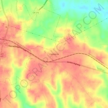
Name: Campania topographic map, elevation, terrain.
Location: Campania, Columbia County, Georgia, 30814, United States (33.39069 -82.31012 33.43069 -82.27012)
Average elevation: 147 m
Minimum elevation: 103 m
Maximum elevation: 171 m
Make a donation
Gear up for your next adventure:
As an Amazon Associate, this site earns from qualifying purchases at no extra cost to you.
Other topographic maps
Click on a map to view its topography, its elevation and its terrain.
Martinez
United States > Georgia > Columbia County > Augusta
Martinez has an elevation of 361 feet (110 m) above sea level, about 200 feet (61 m) higher than downtown Augusta. The areas of the CDP closest to the Richmond County line tend to be relatively flat, while land further west is hillier. Trees in Martinez are seen mainly in the subdivisions, as the main roads…
Average elevation: 107 m
Make a donation
Gear up for your next adventure:
As an Amazon Associate, this site earns from qualifying purchases at no extra cost to you.