
Lulie topographic map
Interactive map
Click on the map to display elevation.
About this map
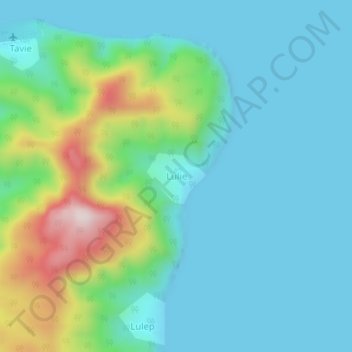
Name: Lulie topographic map, elevation, terrain.
Location: Lulie, Malampa, Vanuatu (-16.46787 168.23466 -16.42787 168.27466)
Average elevation: 116 m
Minimum elevation: 0 m
Maximum elevation: 523 m
Other topographic maps
Click on a map to view its topography, its elevation and its terrain.
Ambrym
While at higher elevations cinder cones predominate, the western tip of the island is characterized by a series of basaltic tuff rings, of which the largest is about 1 kilometre (0.62 mi) in diameter. These were produced by phreatic eruptions when magma contacted the water table and water-saturated sediments…
Average elevation: 121 m