Geolocate

Lawa topographic map

Interactive map

Click on the map to display elevation.

About this map

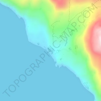
Name: Lawa topographic map, elevation, terrain.

Location: Lawa, Malampa, Vanuatu (-16.44702 167.42529 -16.44448 167.43066)

Average elevation: 81 m

Minimum elevation: 0 m

Maximum elevation: 381 m

Other topographic maps

Click on a map to view its topography, its elevation and its terrain.

Vao Island

Vanuatu > Malampa > Vao

Average elevation: 3 m

Utas

Vanuatu > Malampa

Average elevation: 23 m

Lulie

Vanuatu > Malampa

Average elevation: 116 m

Vao Mainland

Vanuatu > Malampa

Average elevation: 28 m

Ulei

Vanuatu > Malampa

Average elevation: 32 m

Wuro

Vanuatu > Malampa > Craig Cove (Fali)

Average elevation: 41 m

WalaRano Mainland

Vanuatu > Malampa

Average elevation: 23 m

Ranvergere

Vanuatu > Malampa

Average elevation: 38 m

Yelahae

Vanuatu > Malampa > Baiap

Average elevation: 44 m