
Owsley County topographic map
Interactive map
Click on the map to display elevation.
About this map
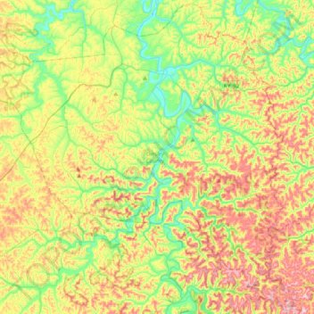
Name: Owsley County topographic map, elevation, terrain.
Location: Owsley County, Kentucky, États-Unis (37.25612 -83.88822 37.54128 -83.52133)
Average elevation: 321 m
Minimum elevation: 193 m
Maximum elevation: 502 m
Other topographic maps
Click on a map to view its topography, its elevation and its terrain.
Morgan
États-Unis > Kentucky > Morgan
Morgan, Comté de Pendleton, Kentucky, États-Unis
Average elevation: 204 m
Booneville
États-Unis > Kentucky > Booneville
Booneville, Owsley County, Kentucky, États-Unis
Average elevation: 238 m
Pikeville
États-Unis > Kentucky > Pikeville
Pikeville, Pike County, Kentucky, États-Unis
Average elevation: 338 m
Crescent Springs
États-Unis > Kentucky > Crescent Springs
Crescent Springs, Comté de Kenton, Kentucky, États-Unis
Average elevation: 242 m
Stonewall
États-Unis > Kentucky > Stonewall
Stonewall, Comté de Bracken, Kentucky, 41044, États-Unis
Average elevation: 249 m