
Femundsee topographic map
Interactive map
Click on the map to display elevation.
About this map
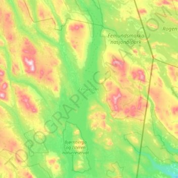
Name: Femundsee topographic map, elevation, terrain.
Location: Femundsee, Innlandet, Norwegen (61.91853 11.70992 62.43409 11.98666)
Average elevation: 822 m
Minimum elevation: 542 m
Maximum elevation: 1,590 m
Other topographic maps
Click on a map to view its topography, its elevation and its terrain.
Søndre Land
Søndre Land, Innlandet, Norwegen, Trollstigen
Average elevation: 459 m
Brumunddal
Brumunddal, Ringsaker, Innlandet, 2382, Norwegen
Average elevation: 259 m
Skeikampen
Skeikampen, Gausdal, Innlandet, 2652, Norwegen
Average elevation: 918 m
Skandinavisches Gebirge
Skandinavisches Gebirge, Lom, Innlandet, Norwegen
Average elevation: 2,050 m