Geolocate

Dharche topographic map

Interactive map

Click on the map to display elevation.

About this map

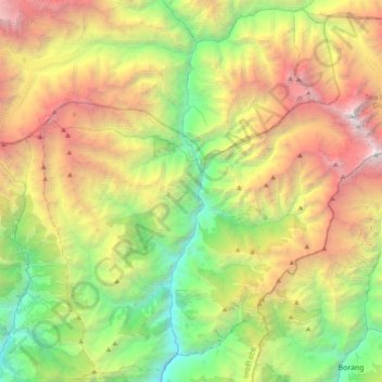
Name: Dharche topographic map, elevation, terrain.

Location: Dharche, Gorkha, Gandaki Province, Nepal (28.15360 84.74824 28.47242 85.12738)

Average elevation: 3,141 m

Minimum elevation: 681 m

Maximum elevation: 7,106 m

Other topographic maps

Click on a map to view its topography, its elevation and its terrain.

Gumda

Nepal > Gandaki Province > Gorkha

Average elevation: 2,021 m

Shyala

Nepal > Gandaki Province > Gorkha

Average elevation: 3,766 m

Jagat

Nepal > Gandaki Province > Gorkha

Average elevation: 1,986 m

Namrung

Nepal > Gandaki Province > Gorkha

Average elevation: 3,197 m

Lho

Nepal > Gandaki Province > Gorkha

Average elevation: 3,714 m

Deng

Nepal > Gandaki Province > Gorkha

Average elevation: 2,569 m

Samagaon

Nepal > Gandaki Province > Gorkha

Average elevation: 3,918 m

Nyak

Nepal > Gandaki Province > Gorkha

Average elevation: 2,320 m

Chum Nubri

Nepal > Gandaki Province > Gorkha

Average elevation: 4,445 m

Barpak

Nepal > Gandaki Province > Gorkha

Average elevation: 1,714 m

Manaslu

Nepal > Gandaki Province > Gorkha

The Manaslu region offers a variety of trekking options. The popular Manaslu trekking route of 177 kilometres (110 mi) skirts the Manaslu massif over the pass down to Annapurna. The Nepalese Government only permitted trekking of this circuit in 1991. The trekking trail follows an ancient salt-trading route…

Average elevation: 7,069 m